Arimís geodata
Arimís (Olancho) is a populated place; located in Honduras in America/Tegucigalpa (GMT-6) time zone. With population of 1,817 people, there are 200 cities with bigger population in this country. Compared to other cities in Honduras, 55.8% of cities are located further ↑North; 93% of cities are located further ←West and 63% of cities have lower elevation than Arimís. Note1


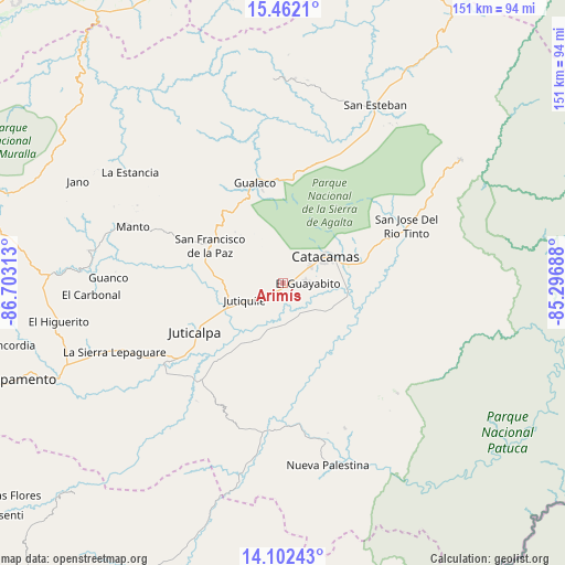
Arimís GPS coordinates[2]
14° 46' 59.988" North, 86° 0' 0" West
| Map corner | latitude | longitude |
|---|---|---|
| Upper-left | 15.4621°, | -86.70313° |
| Center: | 14.78333°, | -86° |
| Lower-right: | 14.10243°, | -85.29688° |
| Map W x H: | 151.2×151.2 km | = 94×94mi |
| max Lat: | 16.45° ⇑55.8% North |
| Arimís: | 14.78333° |
| min Lat: | ⇓44.2% South 13.11667° |
| min Long | Arimís | max Long |
| -89.23333° | -86° | -83.23333° |
| W 93%⇐ | ⇒7% E |
Elevation
Elevation of Arimís is 713 m = 2339 ft, and this is 151.8 m = 498 ft above average elevation for this country.
| Max E: |
1811 m = 5942 ft | 37% |
| Arimís | 713 m 2339 ft | |
| Avg. | 561.2 m = 1841 ft | |
Min E: |
1 m = 3 ft | 63% |
See also: Honduras elevation on elevation.city.
Geographical zone
Arimís is located in North Torrid zone (between Equator and Tropic of Cancer). Distance of this Northern Tropic circle is 962.2 km =597.9 mi to North.| Distance of | km | miles | from Arimís |
|---|---|---|---|
| North Pole | 8363.3 | 5196.7 | to North |
| Arctic Circle | 5757.4 | 3577.5 | to North |
| Tropic Cancer | 962.2 | 597.9 | to North |
| Equator | 1643.8 | 1021.4 | to South |


Nearby cities:
15 places around Arimís: (largest is in red/bold)
• El Guayabito
6.6 km =4.1 mi,  327°
327°
• Gualaco
27.9 km =17.3 mi,  344°
344°
• Guarizama
38.8 km =24.1 mi,  292°
292°
• Juticalpa
26.9 km =16.7 mi,  241°
241°
• Jutiquile
11.6 km =7.2 mi,  230°
230°
• La Concepción
26.7 km =16.6 mi,  249°
249°
• La Empalizada
20.6 km =12.8 mi,  224°
224°
• Laguna Seca
14.2 km =8.8 mi, 229°
• Punuare
6.6 km =4.1 mi,  147°
147°
• San Francisco de Becerra
19.8 km =12.3 mi,  212°
212°
• San Francisco de la Paz
25.1 km =15.6 mi,  301°
301°
• San José de Río Tinto
36.3 km =22.6 mi,  62°
62°
• San Nicolás
37.4 km =23.2 mi, 226°
• Santa María del Real
5.7 km =3.5 mi,  109°
109°
• Zopilotepe
35.2 km =21.9 mi, 234°
Sources, notices
• [Note1] Compared only with cities in Honduras existing in our database
• [Src1] Map data: © OpenStreetMap contributors (CC-BY-SA)
• [Src2] Other city data from geonames.org with taken over terms of usage.
• [Src3] Geographical zone / Annual Mean Temperature by Robert A. Rohde @ Wikipedia
