Manto geodata
Manto (Olancho) is a populated place; located in Honduras in America/Tegucigalpa (GMT-6) time zone. With population of 1,098 people, there are 363 cities with bigger population in this country. Compared to other cities in Honduras, 52% of cities are located further ↓South; 87.4% of cities are located further ←West and 57.8% of cities have lower elevation than Manto. Note1


Manto GPS coordinates[2]
14° 55' 0.012" North, 86° 22' 59.988" West
| Map corner | latitude | longitude |
|---|---|---|
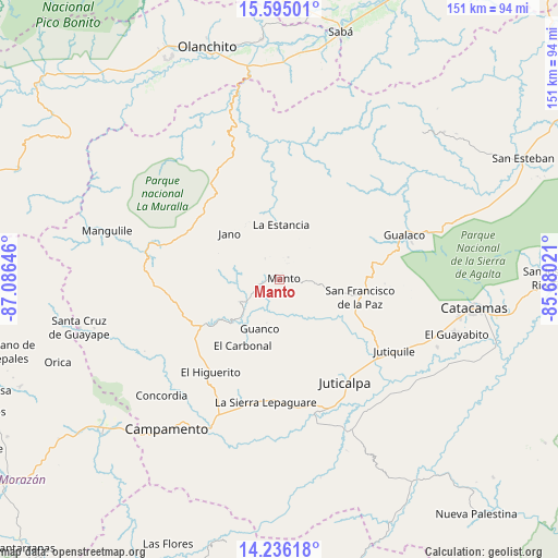
| Upper-left | 15.59501°, | -87.08646° |
| Center: | 14.91667°, | -86.38333° |
| Lower-right: | 14.23618°, | -85.68021° |
| Map W x H: | 151.1×151.1 km | = 93.9×93.9mi |
| max Lat: | 16.45° ⇑48% North |
| Manto: | 14.91667° |
| min Lat: | ⇓52% South 13.11667° |
| min Long | Manto | max Long |
| -89.23333° | -86.38333° | -83.23333° |
| W 87.4%⇐ | ⇒12.6% E |
Elevation
Elevation of Manto is 658 m = 2159 ft, and this is 96.8 m = 318 ft above average elevation for this country.
| Max E: |
1811 m = 5942 ft | 42.2% |
| Manto | 658 m 2159 ft | |
| Avg. | 561.2 m = 1841 ft | |
Min E: |
1 m = 3 ft | 57.8% |
See also: Honduras elevation on elevation.city.
Geographical zone
Manto is located in North Torrid zone (between Equator and Tropic of Cancer). Distance of this Northern Tropic circle is 947.3 km =588.6 mi to North.| Distance of | km | miles | from Manto |
|---|---|---|---|
| North Pole | 8348.5 | 5187.5 | to North |
| Arctic Circle | 5742.6 | 3568.3 | to North |
| Tropic Cancer | 947.3 | 588.6 | to North |
| Equator | 1658.6 | 1030.6 | to South |


Nearby cities:
15 places around Manto: (largest is in red/bold)
• El Guayabito
38.7 km =24 mi,  103°
103°
• El Rosario
32.3 km =20.1 mi,  266°
266°
• Gualaco
35.7 km =22.2 mi,  70°
70°
• Guarizama
5.4 km =3.4 mi,  90°
90°
• Juticalpa
32.9 km =20.4 mi,  147°
147°
• Jutiquile
39.2 km =24.4 mi,  124°
124°
• La Concepción
29 km =18 mi, 146°
• La Empalizada
40 km =24.9 mi,  137°
137°
• La Estancia
15.3 km =9.5 mi,  13°
13°
• La Guata
18.5 km =11.5 mi,  0°
0°
• Laguna Seca
38.8 km =24.1 mi,  128°
128°
• Salamá
23.4 km =14.5 mi,  246°
246°
• San Francisco de la Paz
19.8 km =12.3 mi, 95°
• Silca
18.6 km =11.6 mi,  240°
240°
• Zopilotepe
37.4 km =23.2 mi,  160°
160°
Sources, notices
• [Note1] Compared only with cities in Honduras existing in our database
• [Src1] Map data: © OpenStreetMap contributors (CC-BY-SA)
• [Src2] Other city data from geonames.org with taken over terms of usage.
• [Src3] Geographical zone / Annual Mean Temperature by Robert A. Rohde @ Wikipedia
