Talanga geodata
Talanga (Francisco Morazán) is a populated place; located in Honduras in America/Tegucigalpa (GMT-6) time zone. With population of 13,492 people, there are 27 cities with bigger population in this country. Compared to other cities in Honduras, 74.8% of cities are located further ↑North; 71.8% of cities are located further ←West and 74.2% of cities have lower elevation than Talanga. Note1


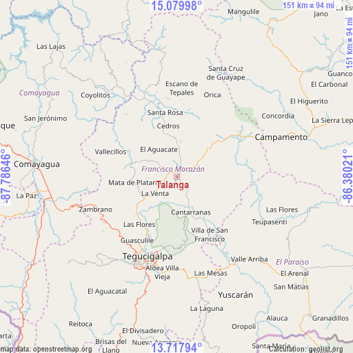
Talanga GPS coordinates[2]
14° 24' 0" North, 87° 4' 59.988" West
| Map corner | latitude | longitude |
|---|---|---|
| Upper-left | 15.07998°, | -87.78646° |
| Center: | 14.4°, | -87.08333° |
| Lower-right: | 13.71794°, | -86.38021° |
| Map W x H: | 151.4×151.4 km | = 94.1×94.1mi |
| max Lat: | 16.45° ⇑74.8% North |
| Talanga: | 14.4° |
| min Lat: | ⇓25.2% South 13.11667° |
| min Long | Talanga | max Long |
| -89.23333° | -87.08333° | -83.23333° |
| W 71.8%⇐ | ⇒28.2% E |
Elevation
Elevation of Talanga is 810 m = 2657 ft, and this is 248.8 m = 816 ft above average elevation for this country.
| Max E: |
1811 m = 5942 ft | 25.8% |
| Talanga | 810 m 2657 ft | |
| Avg. | 561.2 m = 1841 ft | |
Min E: |
1 m = 3 ft | 74.2% |
See also: Honduras elevation on elevation.city.
Geographical zone
Talanga is located in North Torrid zone (between Equator and Tropic of Cancer). Distance of this Northern Tropic circle is 1004.8 km =624.4 mi to North.| Distance of | km | miles | from Talanga |
|---|---|---|---|
| North Pole | 8405.9 | 5223.2 | to North |
| Arctic Circle | 5800 | 3604 | to North |
| Tropic Cancer | 1004.8 | 624.4 | to North |
| Equator | 1601.1 | 994.9 | to South |


Nearby cities:
15 places around Talanga: (largest is in red/bold)
• Agalteca
20.5 km =12.7 mi,  285°
285°
• Cedros
22.5 km =14 mi,  350°
350°
• Cofradía
23.1 km =14.4 mi,  207°
207°
• El Chimbo
29.9 km =18.6 mi,  186°
186°
• El Escanito
29.7 km =18.5 mi,  356°
356°
• El Guante
16.8 km =10.4 mi, 353°
• El Suyatal
19.3 km =12 mi,  312°
312°
• La Ermita
7.6 km =4.7 mi,  13°
13°
• Pueblo Nuevo
21.6 km =13.4 mi,  265°
265°
• Río Abajo
29.7 km =18.5 mi, 208°
• San Ignacio
28.3 km =17.6 mi, 10°
• San Juan de Flores
15.8 km =9.8 mi,  160°
160°
• San Juancito
20.5 km =12.7 mi,  174°
174°
• Valle de Ángeles
28.3 km =17.6 mi, 169°
• Villa de San Francisco
28.8 km =17.9 mi,  154°
154°
Sources, notices
• [Note1] Compared only with cities in Honduras existing in our database
• [Src1] Map data: © OpenStreetMap contributors (CC-BY-SA)
• [Src2] Other city data from geonames.org with taken over terms of usage.
• [Src3] Geographical zone / Annual Mean Temperature by Robert A. Rohde @ Wikipedia
