Pueblo Nuevo geodata
Pueblo Nuevo (Francisco Morazán) is a populated place; located in Honduras in America/Tegucigalpa (GMT-6) time zone. With population of 958 people, there are 442 cities with bigger population in this country. Compared to other cities in Honduras, 75.6% of cities are located further ↑North; 62.2% of cities are located further ←West and 85.4% of cities have lower elevation than Pueblo Nuevo. Note1


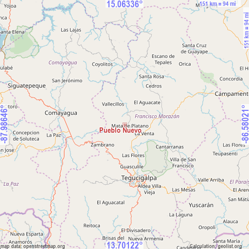
Pueblo Nuevo GPS coordinates[2]
14° 22' 59.988" North, 87° 16' 59.988" West
| Map corner | latitude | longitude |
|---|---|---|
| Upper-left | 15.06336°, | -87.98646° |
| Center: | 14.38333°, | -87.28333° |
| Lower-right: | 13.70122°, | -86.58021° |
| Map W x H: | 151.5×151.5 km | = 94.1×94.1mi |
| max Lat: | 16.45° ⇑75.6% North |
| Pueblo Nuevo: | 14.38333° |
| min Lat: | ⇓24.4% South 13.11667° |
| min Long | Pueblo Nuevo | max Long |
| -89.23333° | -87.28333° | -83.23333° |
| W 62.2%⇐ | ⇒37.8% E |
Elevation
Elevation of Pueblo Nuevo is 1053 m = 3455 ft, and this is 491.8 m = 1614 ft above average elevation for this country.
| Max E: |
1811 m = 5942 ft | 14.6% |
| Pueblo Nuevo | 1053 m 3455 ft | |
| Avg. | 561.2 m = 1841 ft | |
Min E: |
1 m = 3 ft | 85.4% |
See also: Honduras elevation on elevation.city.
Geographical zone
Pueblo Nuevo is located in North Torrid zone (between Equator and Tropic of Cancer). Distance of this Northern Tropic circle is 1006.6 km =625.5 mi to North.| Distance of | km | miles | from Pueblo Nuevo |
|---|---|---|---|
| North Pole | 8407.8 | 5224.4 | to North |
| Arctic Circle | 5801.9 | 3605.1 | to North |
| Tropic Cancer | 1006.6 | 625.5 | to North |
| Equator | 1599.3 | 993.8 | to South |


Nearby cities:
15 places around Pueblo Nuevo: (largest is in red/bold)
• Agalteca
7.6 km =4.7 mi,  13°
13°
• Cofradía
21.4 km =13.3 mi,  149°
149°
• El Durazno
27.9 km =17.3 mi,  176°
176°
• El Guante
27.1 km =16.8 mi,  46°
46°
• El Guantillo
24.2 km =15 mi,  355°
355°
• El Lolo
29.7 km =18.5 mi, 176°
• El Suyatal
16.5 km =10.3 mi,  25°
25°
• La Ermita
25.1 km =15.6 mi,  68°
68°
• Mata de Plátano
24.1 km =15 mi,  0°
0°
• Quebradas
14.8 km =9.2 mi,  331°
331°
• Río Abajo
25.1 km =15.6 mi,  163°
163°
• Talanga
21.6 km =13.4 mi,  85°
85°
• Támara
26.5 km =16.5 mi,  191°
191°
• Vallecillo
19.4 km =12.1 mi,  319°
319°
• Zambrano
18.1 km =11.2 mi,  224°
224°
Sources, notices
• [Note1] Compared only with cities in Honduras existing in our database
• [Src1] Map data: © OpenStreetMap contributors (CC-BY-SA)
• [Src2] Other city data from geonames.org with taken over terms of usage.
• [Src3] Geographical zone / Annual Mean Temperature by Robert A. Rohde @ Wikipedia
