El Guante geodata
El Guante (Francisco Morazán) is a populated place; located in Honduras in America/Tegucigalpa (GMT-6) time zone. With population of 1,082 people, there are 372 cities with bigger population in this country. Compared to other cities in Honduras, 68.8% of cities are located further ↑North; 71.2% of cities are located further ←West and 77.2% of cities have lower elevation than El Guante. Note1


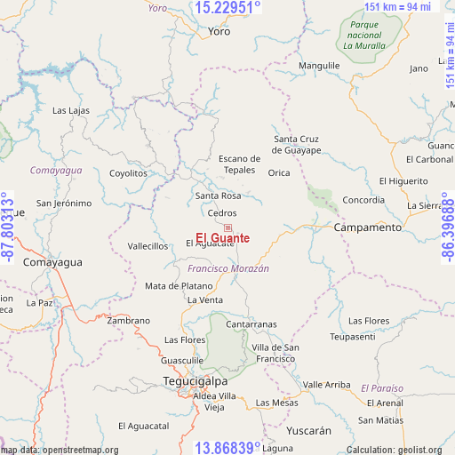
El Guante GPS coordinates[2]
14° 33' 0" North, 87° 6' 0" West
| Map corner | latitude | longitude |
|---|---|---|
| Upper-left | 15.22951°, | -87.80313° |
| Center: | 14.55°, | -87.1° |
| Lower-right: | 13.86839°, | -86.39688° |
| Map W x H: | 151.3×151.3 km | = 94×94mi |
| max Lat: | 16.45° ⇑68.8% North |
| El Guante: | 14.55° |
| min Lat: | ⇓31.2% South 13.11667° |
| min Long | El Guante | max Long |
| -89.23333° | -87.1° | -83.23333° |
| W 71.2%⇐ | ⇒28.8% E |
Elevation
Elevation of El Guante is 881 m = 2890 ft, and this is 319.8 m = 1049 ft above average elevation for this country.
| Max E: |
1811 m = 5942 ft | 22.8% |
| El Guante | 881 m 2890 ft | |
| Avg. | 561.2 m = 1841 ft | |
Min E: |
1 m = 3 ft | 77.2% |
See also: Honduras elevation on elevation.city.
Geographical zone
El Guante is located in North Torrid zone (between Equator and Tropic of Cancer). Distance of this Northern Tropic circle is 988.1 km =614 mi to North.| Distance of | km | miles | from El Guante |
|---|---|---|---|
| North Pole | 8389.3 | 5212.9 | to North |
| Arctic Circle | 5783.4 | 3593.6 | to North |
| Tropic Cancer | 988.1 | 614 | to North |
| Equator | 1617.8 | 1005.3 | to South |


Nearby cities:
15 places around El Guante: (largest is in red/bold)
• Agalteca
21.1 km =13.1 mi,  238°
238°
• Cedros
5.8 km =3.6 mi,  342°
342°
• El Escanito
13 km =8.1 mi,  0°
0°
• El Escaño de Tepale
22.5 km =14 mi,  9°
9°
• El Guantillo
22.2 km =13.8 mi,  284°
284°
• El Pedernal
16.8 km =10.4 mi,  353°
353°
• El Suyatal
13.1 km =8.1 mi,  253°
253°
• La Ermita
9.9 km =6.2 mi,  158°
158°
• Mata de Plátano
20.5 km =12.7 mi,  285°
285°
• Orica
23.2 km =14.4 mi,  44°
44°
• Pueblo Nuevo
27.1 km =16.8 mi,  226°
226°
• Quebradas
27.5 km =17.1 mi,  258°
258°
• San Ignacio
13.2 km =8.2 mi,  32°
32°
• Talanga
16.8 km =10.4 mi,  173°
173°
• Urrutia
23.4 km =14.5 mi,  17°
17°
Sources, notices
• [Note1] Compared only with cities in Honduras existing in our database
• [Src1] Map data: © OpenStreetMap contributors (CC-BY-SA)
• [Src2] Other city data from geonames.org with taken over terms of usage.
• [Src3] Geographical zone / Annual Mean Temperature by Robert A. Rohde @ Wikipedia
