Siguatepeque geodata
Siguatepeque (Comayagua) is a populated place; located in Honduras in America/Tegucigalpa (GMT-6) time zone. With population of 43,141 people, there are 10 cities with bigger population in this country. Compared to other cities in Honduras, 66.8% of cities are located further ↑North; 57% of cities are located further →East and 86.2% of cities have lower elevation than Siguatepeque. Note1


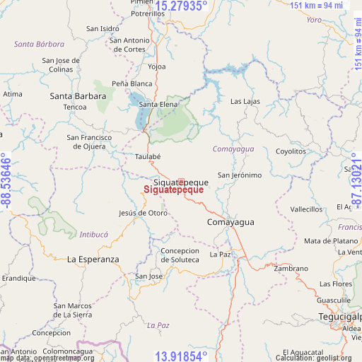
Siguatepeque GPS coordinates[2]
14° 36' 0" North, 87° 49' 59.988" West
| Map corner | latitude | longitude |
|---|---|---|
| Upper-left | 15.27935°, | -88.53646° |
| Center: | 14.6°, | -87.83333° |
| Lower-right: | 13.91854°, | -87.13021° |
| Map W x H: | 151.3×151.3 km | = 94×94mi |
| max Lat: | 16.45° ⇑66.8% North |
| Siguatepeque: | 14.6° |
| min Lat: | ⇓33.2% South 13.11667° |
| min Long | Siguatepeque | max Long |
| -89.23333° | -87.83333° | -83.23333° |
| W 43%⇐ | ⇒57% E |
Elevation
Elevation of Siguatepeque is 1079 m = 3540 ft, and this is 517.8 m = 1699 ft above average elevation for this country.
| Max E: |
1811 m = 5942 ft | 13.8% |
| Siguatepeque | 1079 m 3540 ft | |
| Avg. | 561.2 m = 1841 ft | |
Min E: |
1 m = 3 ft | 86.2% |
See also: Siguatepeque elevation on elevation.city.
Geographical zone
Siguatepeque is located in North Torrid zone (between Equator and Tropic of Cancer). Distance of this Northern Tropic circle is 982.6 km =610.6 mi to North.| Distance of | km | miles | from Siguatepeque |
|---|---|---|---|
| North Pole | 8383.7 | 5209.4 | to North |
| Arctic Circle | 5777.8 | 3590.2 | to North |
| Tropic Cancer | 982.6 | 610.6 | to North |
| Equator | 1623.4 | 1008.7 | to South |


Nearby cities:
15 places around Siguatepeque: (largest is in red/bold)
• Aguas del Padre
6.5 km =4 mi,  235°
235°
• Cerro Blanco
9.2 km =5.7 mi,  35°
35°
• Concepción de Guasistagua
19.7 km =12.2 mi,  90°
90°
• El Agua Dulcita
14.3 km =8.9 mi, 38°
• El Porvenir
5.7 km =3.5 mi,  250°
250°
• El Rincón
10.9 km =6.8 mi,  260°
260°
• El Sauce
19.7 km =12.2 mi,  113°
113°
• El Socorro
9.7 km =6 mi,  292°
292°
• Jardines
19.6 km =12.2 mi,  304°
304°
• Ojos de Agua
10.8 km =6.7 mi,  270°
270°
• Palo Pintado
18.6 km =11.6 mi,  119°
119°
• Potrerillos
6.6 km =4.1 mi,  212°
212°
• Río Bonito
19.3 km =12 mi,  343°
343°
• San José de Pane
13 km =8.1 mi,  180°
180°
• Taulabé
18.1 km =11.2 mi,  307°
307°
Sources, notices
• [Note1] Compared only with cities in Honduras existing in our database
• [Src1] Map data: © OpenStreetMap contributors (CC-BY-SA)
• [Src2] Other city data from geonames.org with taken over terms of usage.
• [Src3] Geographical zone / Annual Mean Temperature by Robert A. Rohde @ Wikipedia
