El Sauce geodata
El Sauce (Comayagua) is a populated place; located in Honduras in America/Tegucigalpa (GMT-6) time zone. With population of 1,389 people, there are 269 cities with bigger population in this country. Compared to other cities in Honduras, 69.4% of cities are located further ↑North; 51.6% of cities are located further →East and 52.6% of cities have lower elevation than El Sauce. Note1


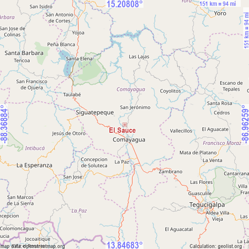
El Sauce GPS coordinates[2]
14° 31' 42.6" North, 87° 39' 56.556" West
| Map corner | latitude | longitude |
|---|---|---|
| Upper-left | 15.20808°, | -88.36884° |
| Center: | 14.5285°, | -87.66571° |
| Lower-right: | 13.84683°, | -86.96259° |
| Map W x H: | 151.4×151.4 km | = 94.1×94.1mi |
| max Lat: | 16.45° ⇑69.4% North |
| El Sauce: | 14.5285° |
| min Lat: | ⇓30.6% South 13.11667° |
| min Long | El Sauce | max Long |
| -89.23333° | -87.66571° | -83.23333° |
| W 48.4%⇐ | ⇒51.6% E |
Elevation
Elevation of El Sauce is 595 m = 1952 ft, and this is 33.8 m = 111 ft above average elevation for this country.
| Max E: |
1811 m = 5942 ft | 47.4% |
| El Sauce | 595 m 1952 ft | |
| Avg. | 561.2 m = 1841 ft | |
Min E: |
1 m = 3 ft | 52.6% |
See also: Honduras elevation on elevation.city.
Geographical zone
El Sauce is located in North Torrid zone (between Equator and Tropic of Cancer). Distance of this Northern Tropic circle is 990.5 km =615.5 mi to North.| Distance of | km | miles | from El Sauce |
|---|---|---|---|
| North Pole | 8391.6 | 5214.3 | to North |
| Arctic Circle | 5785.8 | 3595.1 | to North |
| Tropic Cancer | 990.5 | 615.5 | to North |
| Equator | 1615.4 | 1003.8 | to South |


Nearby cities:
15 places around El Sauce: (largest is in red/bold)
• Ajuterique
16.6 km =10.3 mi,  192°
192°
• Cerro Blanco
19.9 km =12.4 mi,  320°
320°
• Comayagua
9.1 km =5.7 mi,  160°
160°
• Concepción de Guasistagua
8.1 km =5 mi,  12°
12°
• El Agua Dulcita
21.1 km =13.1 mi,  334°
334°
• Jamalteca
21 km =13 mi,  24°
24°
• La Trinidad
20.9 km =13 mi,  359°
359°
• Lejamaní
18.4 km =11.4 mi, 191°
• Palo Pintado
2.3 km =1.4 mi,  235°
235°
• Potrerillos
21.8 km =13.5 mi,  276°
276°
• San Antonio de la Cuesta
13.6 km =8.5 mi,  31°
31°
• San Jerónimo
13.6 km =8.5 mi, 31°
• San José de Pane
18.7 km =11.6 mi,  254°
254°
• Siguatepeque
19.7 km =12.2 mi,  293°
293°
• Valle de Ángeles
4.7 km =2.9 mi,  132°
132°
Sources, notices
• [Note1] Compared only with cities in Honduras existing in our database
• [Src1] Map data: © OpenStreetMap contributors (CC-BY-SA)
• [Src2] Other city data from geonames.org with taken over terms of usage.
• [Src3] Geographical zone / Annual Mean Temperature by Robert A. Rohde @ Wikipedia
