Palo Pintado geodata
Palo Pintado (Comayagua) is a populated place; located in Honduras in America/Tegucigalpa (GMT-6) time zone. With population of 909 people, there are 473 cities with bigger population in this country. Compared to other cities in Honduras, 70.6% of cities are located further ↑North; 52.6% of cities are located further →East and 51.2% of cities have higher elevation than Palo Pintado. Note1


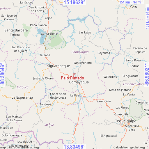
Palo Pintado GPS coordinates[2]
14° 31' 0.012" North, 87° 40' 59.988" West
| Map corner | latitude | longitude |
|---|---|---|
| Upper-left | 15.19629°, | -88.38646° |
| Center: | 14.51667°, | -87.68333° |
| Lower-right: | 13.83496°, | -86.98021° |
| Map W x H: | 151.4×151.4 km | = 94.1×94.1mi |
| max Lat: | 16.45° ⇑70.6% North |
| Palo Pintado: | 14.51667° |
| min Lat: | ⇓29.4% South 13.11667° |
| min Long | Palo Pintado | max Long |
| -89.23333° | -87.68333° | -83.23333° |
| W 47.4%⇐ | ⇒52.6% E |
Elevation
Elevation of Palo Pintado is 549 m = 1801 ft, and this is 12.2 m = 40 ft below average elevation for this country.
| Max E: |
1811 m = 5942 ft | 51.2% |
| Avg. | 561.2 m = 1841 ft | |
| Palo Pintado | 549 m = 1801 ft | |
Min E: |
1 m = 3 ft | 48.8% |
See also: Honduras elevation on elevation.city.
Geographical zone
Palo Pintado is located in North Torrid zone (between Equator and Tropic of Cancer). Distance of this Northern Tropic circle is 991.8 km =616.3 mi to North.| Distance of | km | miles | from Palo Pintado |
|---|---|---|---|
| North Pole | 8393 | 5215.2 | to North |
| Arctic Circle | 5787.1 | 3595.9 | to North |
| Tropic Cancer | 991.8 | 616.3 | to North |
| Equator | 1614.1 | 1003 | to South |


Nearby cities:
15 places around Palo Pintado: (largest is in red/bold)
• Ajuterique
14.9 km =9.3 mi,  186°
186°
• Cerro Blanco
19.8 km =12.3 mi,  327°
327°
• Comayagua
8.8 km =5.5 mi,  145°
145°
• Concepción de Guasistagua
9.9 km =6.2 mi,  21°
21°
• El Agua Dulcita
21.6 km =13.4 mi,  340°
340°
• El Sauce
2.3 km =1.4 mi,  55°
55°
• Lejamaní
16.8 km =10.4 mi, 186°
• Potrerillos
20.1 km =12.5 mi,  280°
280°
• San Antonio de la Cuesta
15.8 km =9.8 mi,  34°
34°
• San Jerónimo
15.8 km =9.8 mi, 34°
• San José de Pane
16.6 km =10.3 mi,  257°
257°
• Siguatepeque
18.6 km =11.6 mi,  299°
299°
• Tepanguare
21.6 km =13.4 mi,  199°
199°
• Valle de Ángeles
5.7 km =3.5 mi,  109°
109°
• Yarumela
21.1 km =13.1 mi,  165°
165°
Sources, notices
• [Note1] Compared only with cities in Honduras existing in our database
• [Src1] Map data: © OpenStreetMap contributors (CC-BY-SA)
• [Src2] Other city data from geonames.org with taken over terms of usage.
• [Src3] Geographical zone / Annual Mean Temperature by Robert A. Rohde @ Wikipedia
