San Nicolás geodata
San Nicolás (Copán) is a populated place; located in Honduras in America/Tegucigalpa (GMT-6) time zone. With population of 2,231 people, there are 162 cities with bigger population in this country. Compared to other cities in Honduras, 57.2% of cities are located further ↓South; 89.8% of cities are located further →East and 64.2% of cities have lower elevation than San Nicolás. Note1


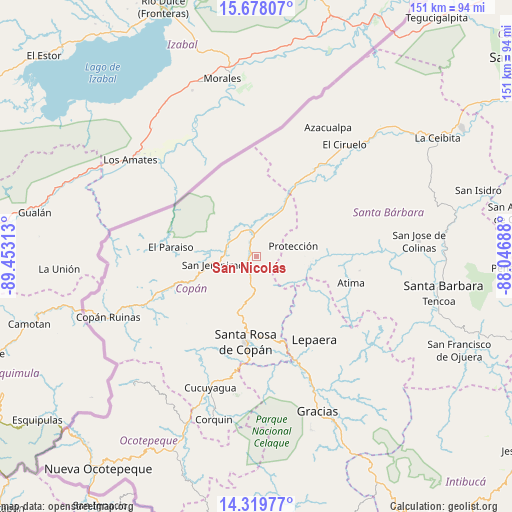
San Nicolás GPS coordinates[2]
15° 0' 0" North, 88° 45' 0" West
| Map corner | latitude | longitude |
|---|---|---|
| Upper-left | 15.67807°, | -89.45313° |
| Center: | 15°, | -88.75° |
| Lower-right: | 14.31977°, | -88.04688° |
| Map W x H: | 151×151 km | = 93.8×93.8mi |
| max Lat: | 16.45° ⇑42.8% North |
| San Nicolás: | 15° |
| min Lat: | ⇓57.2% South 13.11667° |
| min Long | San Nicolás | max Long |
| -89.23333° | -88.75° | -83.23333° |
| W 10.2%⇐ | ⇒89.8% E |
Elevation
Elevation of San Nicolás is 724 m = 2375 ft, and this is 162.8 m = 534 ft above average elevation for this country.
| Max E: |
1811 m = 5942 ft | 35.8% |
| San Nicolás | 724 m 2375 ft | |
| Avg. | 561.2 m = 1841 ft | |
Min E: |
1 m = 3 ft | 64.2% |
See also: Honduras elevation on elevation.city.
Geographical zone
San Nicolás is located in North Torrid zone (between Equator and Tropic of Cancer). Distance of this Northern Tropic circle is 938.1 km =582.9 mi to North.| Distance of | km | miles | from San Nicolás |
|---|---|---|---|
| North Pole | 8339.2 | 5181.7 | to North |
| Arctic Circle | 5733.3 | 3562.5 | to North |
| Tropic Cancer | 938.1 | 582.9 | to North |
| Equator | 1667.8 | 1036.3 | to South |


Nearby cities:
15 places around San Nicolás: (largest is in red/bold)
• Agua Caliente
14.8 km =9.2 mi,  208°
208°
• Chalmeca
13.2 km =8.2 mi,  32°
32°
• Florida
9.7 km =6 mi,  292°
292°
• La Entrada
5.8 km =3.6 mi,  17°
17°
• La Jigua
6.5 km =4 mi,  304°
304°
• Naranjito
9.1 km =5.7 mi,  127°
127°
• Protección
11.4 km =7.1 mi,  70°
70°
• Pueblo Nuevo
0 km =0 mi,  0°
0°
• Quezailica
13.1 km =8.1 mi,  172°
172°
• San Jerónimo
13.1 km =8.1 mi,  253°
253°
• San José de Copán
11.7 km =7.3 mi,  162°
162°
• San Juan de Planes
8.2 km =5.1 mi, 205°
• Trinidad de Copán
5.6 km =3.5 mi,  180°
180°
• Veracruz
9.9 km =6.2 mi,  201°
201°
• Vivistorio
11.3 km =7 mi, 170°
Sources, notices
• [Note1] Compared only with cities in Honduras existing in our database
• [Src1] Map data: © OpenStreetMap contributors (CC-BY-SA)
• [Src2] Other city data from geonames.org with taken over terms of usage.
• [Src3] Geographical zone / Annual Mean Temperature by Robert A. Rohde @ Wikipedia
