Veracruz geodata
Veracruz (Copán) is a populated place; located in Honduras in America/Tegucigalpa (GMT-6) time zone. With population of 1,045 people, there are 393 cities with bigger population in this country. Compared to other cities in Honduras, 52% of cities are located further ↓South; 90.8% of cities are located further →East and 88.6% of cities have lower elevation than Veracruz. Note1


Veracruz GPS coordinates[2]
14° 55' 0.012" North, 88° 46' 59.988" West
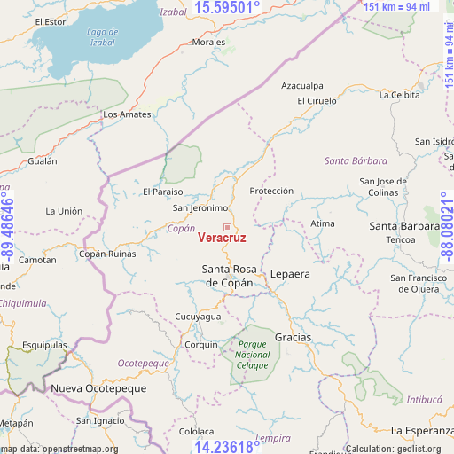
| Map corner | latitude | longitude |
|---|---|---|
| Upper-left | 15.59501°, | -89.48646° |
| Center: | 14.91667°, | -88.78333° |
| Lower-right: | 14.23618°, | -88.08021° |
| Map W x H: | 151.1×151.1 km | = 93.9×93.9mi |
| max Lat: | 16.45° ⇑48% North |
| Veracruz: | 14.91667° |
| min Lat: | ⇓52% South 13.11667° |
| min Long | Veracruz | max Long |
| -89.23333° | -88.78333° | -83.23333° |
| W 9.2%⇐ | ⇒90.8% E |
Elevation
Elevation of Veracruz is 1128 m = 3701 ft, and this is 566.8 m = 1860 ft above average elevation for this country.
| Max E: |
1811 m = 5942 ft | 11.4% |
| Veracruz | 1128 m 3701 ft | |
| Avg. | 561.2 m = 1841 ft | |
Min E: |
1 m = 3 ft | 88.6% |
See also: Honduras elevation on elevation.city.
Geographical zone
Veracruz is located in North Torrid zone (between Equator and Tropic of Cancer). Distance of this Northern Tropic circle is 947.3 km =588.6 mi to North.| Distance of | km | miles | from Veracruz |
|---|---|---|---|
| North Pole | 8348.5 | 5187.5 | to North |
| Arctic Circle | 5742.6 | 3568.3 | to North |
| Tropic Cancer | 947.3 | 588.6 | to North |
| Equator | 1658.6 | 1030.6 | to South |


Nearby cities:
15 places around Veracruz: (largest is in red/bold)
• Agua Caliente
5.2 km =3.2 mi,  224°
224°
• Dolores
7.7 km =4.8 mi, 224°
• Dulce Nombre
9.2 km =5.7 mi, 215°
• Florida
14 km =8.7 mi,  337°
337°
• La Entrada
15.8 km =9.8 mi,  19°
19°
• La Jigua
13.1 km =8.1 mi,  352°
352°
• Naranjito
11.4 km =7.1 mi,  70°
70°
• Pueblo Nuevo
9.9 km =6.2 mi, 21°
• Quezailica
6.5 km =4 mi,  124°
124°
• San Jerónimo
10.5 km =6.5 mi,  301°
301°
• San José de Copán
7.4 km =4.6 mi,  104°
104°
• San Juan de Planes
1.9 km =1.2 mi,  0°
0°
• San Nicolás
9.9 km =6.2 mi, 21°
• Trinidad de Copán
5.2 km =3.2 mi,  44°
44°
• Vivistorio
5.7 km =3.5 mi,  109°
109°
Sources, notices
• [Note1] Compared only with cities in Honduras existing in our database
• [Src1] Map data: © OpenStreetMap contributors (CC-BY-SA)
• [Src2] Other city data from geonames.org with taken over terms of usage.
• [Src3] Geographical zone / Annual Mean Temperature by Robert A. Rohde @ Wikipedia
