Río Lindo geodata
Río Lindo (Cortés) is a populated place; located in Honduras in America/Tegucigalpa (GMT-6) time zone. With population of 3,479 people, there are 98 cities with bigger population in this country. Compared to other cities in Honduras, 59.6% of cities are located further ↓South; 67% of cities are located further →East and 75.2% of cities have higher elevation than Río Lindo. Note1


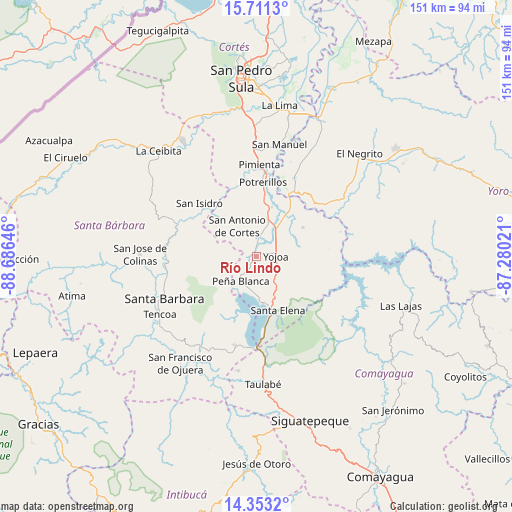
Río Lindo GPS coordinates[2]
15° 1' 59.988" North, 87° 58' 59.988" West
| Map corner | latitude | longitude |
|---|---|---|
| Upper-left | 15.7113°, | -88.68646° |
| Center: | 15.03333°, | -87.98333° |
| Lower-right: | 14.3532°, | -87.28021° |
| Map W x H: | 151×151 km | = 93.8×93.8mi |
| max Lat: | 16.45° ⇑40.4% North |
| Río Lindo: | 15.03333° |
| min Lat: | ⇓59.6% South 13.11667° |
| min Long | Río Lindo | max Long |
| -89.23333° | -87.98333° | -83.23333° |
| W 33%⇐ | ⇒67% E |
Elevation
Elevation of Río Lindo is 145 m = 476 ft, and this is 416.2 m = 1365 ft below average elevation for this country.
| Max E: |
1811 m = 5942 ft | 75.2% |
| Avg. | 561.2 m = 1841 ft | |
| Río Lindo | 145 m = 476 ft | |
Min E: |
1 m = 3 ft | 24.8% |
See also: Honduras elevation on elevation.city.
Geographical zone
Río Lindo is located in North Torrid zone (between Equator and Tropic of Cancer). Distance of this Northern Tropic circle is 934.4 km =580.6 mi to North.| Distance of | km | miles | from Río Lindo |
|---|---|---|---|
| North Pole | 8335.5 | 5179.4 | to North |
| Arctic Circle | 5729.6 | 3560.2 | to North |
| Tropic Cancer | 934.4 | 580.6 | to North |
| Equator | 1671.5 | 1038.6 | to South |


Nearby cities:
15 places around Río Lindo: (largest is in red/bold)
• Agua Azul
13.1 km =8.1 mi,  172°
172°
• Bejuco
12.3 km =7.6 mi,  25°
25°
• Casa Quemada
14.2 km =8.8 mi,  310°
310°
• Cañaveral
6.6 km =4.1 mi,  212°
212°
• El Edén
9.9 km =6.2 mi,  201°
201°
• El Olivar
12.1 km =7.5 mi,  62°
62°
• El Perico
13.7 km =8.5 mi,  293°
293°
• El Tigre
11.1 km =6.9 mi,  180°
180°
• Los Caminos
9.4 km =5.8 mi, 169°
• Oropéndolas
5.7 km =3.5 mi,  109°
109°
• San Antonio de Cortés
10.7 km =6.6 mi,  329°
329°
• San Buenaventura
2.6 km =1.6 mi,  224°
224°
• San Francisco de Yojoa
2.6 km =1.6 mi,  135°
135°
• San José de Oriente
14.3 km =8.9 mi,  270°
270°
• Santa Cruz de Yojoa
10.5 km =6.5 mi,  121°
121°
Sources, notices
• [Note1] Compared only with cities in Honduras existing in our database
• [Src1] Map data: © OpenStreetMap contributors (CC-BY-SA)
• [Src2] Other city data from geonames.org with taken over terms of usage.
• [Src3] Geographical zone / Annual Mean Temperature by Robert A. Rohde @ Wikipedia
