El Perico geodata
El Perico (Cortés) is a populated place; located in Honduras in America/Tegucigalpa (GMT-6) time zone. With population of 1,141 people, there are 341 cities with bigger population in this country. Compared to other cities in Honduras, 63.2% of cities are located further ↓South; 71.8% of cities are located further →East and 78.4% of cities have lower elevation than El Perico. Note1


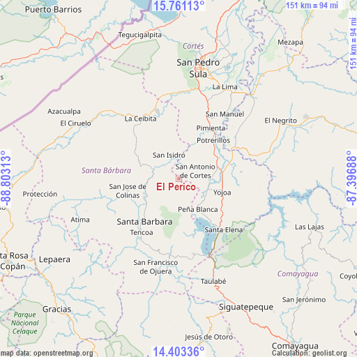
El Perico GPS coordinates[2]
15° 4' 59.988" North, 88° 6' 0" West
| Map corner | latitude | longitude |
|---|---|---|
| Upper-left | 15.76113°, | -88.80313° |
| Center: | 15.08333°, | -88.1° |
| Lower-right: | 14.40336°, | -87.39688° |
| Map W x H: | 151×151 km | = 93.8×93.8mi |
| max Lat: | 16.45° ⇑36.8% North |
| El Perico: | 15.08333° |
| min Lat: | ⇓63.2% South 13.11667° |
| min Long | El Perico | max Long |
| -89.23333° | -88.1° | -83.23333° |
| W 28.2%⇐ | ⇒71.8% E |
Elevation
Elevation of El Perico is 900 m = 2953 ft, and this is 338.8 m = 1112 ft above average elevation for this country.
| Max E: |
1811 m = 5942 ft | 21.6% |
| El Perico | 900 m 2953 ft | |
| Avg. | 561.2 m = 1841 ft | |
Min E: |
1 m = 3 ft | 78.4% |
See also: Honduras elevation on elevation.city.
Geographical zone
El Perico is located in North Torrid zone (between Equator and Tropic of Cancer). Distance of this Northern Tropic circle is 928.8 km =577.1 mi to North.| Distance of | km | miles | from El Perico |
|---|---|---|---|
| North Pole | 8330 | 5176 | to North |
| Arctic Circle | 5724.1 | 3556.8 | to North |
| Tropic Cancer | 928.8 | 577.1 | to North |
| Equator | 1677.1 | 1042.1 | to South |


Nearby cities:
15 places around El Perico: (largest is in red/bold)
• Casa Quemada
4.1 km =2.5 mi,  25°
25°
• Cañaveral
14.3 km =8.9 mi,  141°
141°
• Concepción del Norte
9.9 km =6.2 mi,  338°
338°
• El Edén
17.3 km =10.7 mi,  148°
148°
• Guacamaya
9.2 km =5.7 mi,  215°
215°
• Ilama
12.7 km =7.9 mi,  261°
261°
• Laguna Verde
14.8 km =9.2 mi,  331°
331°
• Nueva Granada
3.7 km =2.3 mi,  0°
0°
• Río Lindo
13.7 km =8.5 mi,  113°
113°
• San Antonio de Cortés
8.1 km =5 mi,  62°
62°
• San Buenaventura
13 km =8.1 mi,  124°
124°
• San Francisco de Yojoa
16.1 km =10 mi, 117°
• San José de Oriente
5.8 km =3.6 mi,  197°
197°
• San Luis de Planes
11.7 km =7.3 mi, 197°
• Trinidad
15.4 km =9.6 mi,  291°
291°
Sources, notices
• [Note1] Compared only with cities in Honduras existing in our database
• [Src1] Map data: © OpenStreetMap contributors (CC-BY-SA)
• [Src2] Other city data from geonames.org with taken over terms of usage.
• [Src3] Geographical zone / Annual Mean Temperature by Robert A. Rohde @ Wikipedia
