Cañaveral geodata
Cañaveral (Cortés) is a populated place; located in Honduras in America/Tegucigalpa (GMT-6) time zone. With population of 2,137 people, there are 168 cities with bigger population in this country. Compared to other cities in Honduras, 56.4% of cities are located further ↓South; 68.6% of cities are located further →East and 54% of cities have higher elevation than Cañaveral. Note1


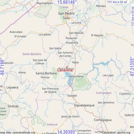
Cañaveral GPS coordinates[2]
14° 58' 59.988" North, 88° 1' 0.012" West
| Map corner | latitude | longitude |
|---|---|---|
| Upper-left | 15.66146°, | -88.7198° |
| Center: | 14.98333°, | -88.01667° |
| Lower-right: | 14.30305°, | -87.31355° |
| Map W x H: | 151×151 km | = 93.8×93.8mi |
| max Lat: | 16.45° ⇑43.6% North |
| Cañaveral: | 14.98333° |
| min Lat: | ⇓56.4% South 13.11667° |
| min Long | Cañaveral | max Long |
| -89.23333° | -88.01667° | -83.23333° |
| W 31.4%⇐ | ⇒68.6% E |
Elevation
Elevation of Cañaveral is 506 m = 1660 ft, and this is 55.2 m = 181 ft below average elevation for this country.
| Max E: |
1811 m = 5942 ft | 54% |
| Avg. | 561.2 m = 1841 ft | |
| Cañaveral | 506 m = 1660 ft | |
Min E: |
1 m = 3 ft | 46% |
See also: Honduras elevation on elevation.city.
Geographical zone
Cañaveral is located in North Torrid zone (between Equator and Tropic of Cancer). Distance of this Northern Tropic circle is 939.9 km =584 mi to North.| Distance of | km | miles | from Cañaveral |
|---|---|---|---|
| North Pole | 8341.1 | 5182.9 | to North |
| Arctic Circle | 5735.2 | 3563.7 | to North |
| Tropic Cancer | 939.9 | 584 | to North |
| Equator | 1666 | 1035.2 | to South |


Nearby cities:
15 places around Cañaveral: (largest is in red/bold)
• Agua Azul
9.2 km =5.7 mi,  144°
144°
• Agua Azul Rancho
11.7 km =7.3 mi, 142°
• El Edén
3.7 km =2.3 mi,  180°
180°
• El Tigre
6.6 km =4.1 mi,  147°
147°
• La Guama
14.3 km =8.9 mi, 141°
• Las Vegas, Santa Barbara
13.4 km =8.3 mi,  207°
207°
• Los Caminos
6.5 km =4 mi,  124°
124°
• Los Naranjos
9.9 km =6.2 mi,  201°
201°
• Oropéndolas
9.7 km =6 mi,  67°
67°
• Río Lindo
6.6 km =4.1 mi,  32°
32°
• San Buenaventura
4.1 km =2.5 mi, 25°
• San Francisco de Yojoa
6.5 km =4 mi,  55°
55°
• San José de Oriente
12.1 km =7.5 mi,  297°
297°
• San Luis de Planes
12.5 km =7.8 mi,  270°
270°
• Santa Cruz de Yojoa
12.5 km =7.8 mi,  90°
90°
Sources, notices
• [Note1] Compared only with cities in Honduras existing in our database
• [Src1] Map data: © OpenStreetMap contributors (CC-BY-SA)
• [Src2] Other city data from geonames.org with taken over terms of usage.
• [Src3] Geographical zone / Annual Mean Temperature by Robert A. Rohde @ Wikipedia
