Quimistán geodata
Quimistán (Santa Bárbara) is a populated place; located in Honduras in America/Tegucigalpa (GMT-6) time zone. With population of 3,517 people, there are 97 cities with bigger population in this country. Compared to other cities in Honduras, 76.2% of cities are located further ↓South; 80.8% of cities are located further →East and 72.2% of cities have higher elevation than Quimistán. Note1


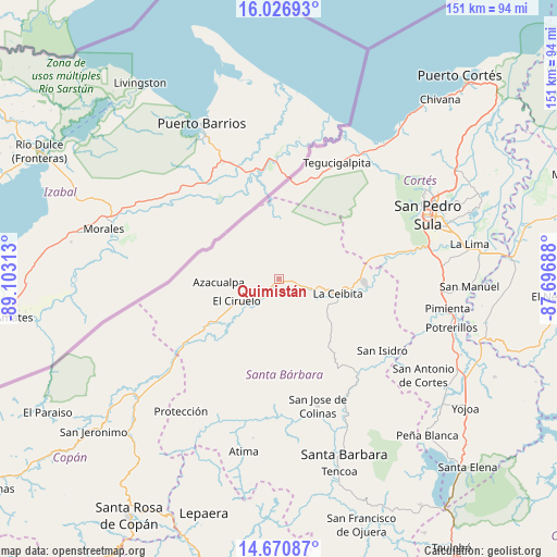
Quimistán GPS coordinates[2]
15° 21' 0" North, 88° 24' 0" West
| Map corner | latitude | longitude |
|---|---|---|
| Upper-left | 16.02693°, | -89.10313° |
| Center: | 15.35°, | -88.4° |
| Lower-right: | 14.67087°, | -87.69688° |
| Map W x H: | 150.8×150.8 km | = 93.7×93.7mi |
| max Lat: | 16.45° ⇑23.8% North |
| Quimistán: | 15.35° |
| min Lat: | ⇓76.2% South 13.11667° |
| min Long | Quimistán | max Long |
| -89.23333° | -88.4° | -83.23333° |
| W 19.2%⇐ | ⇒80.8% E |
Elevation
Elevation of Quimistán is 198 m = 650 ft, and this is 363.2 m = 1192 ft below average elevation for this country.
| Max E: |
1811 m = 5942 ft | 72.2% |
| Avg. | 561.2 m = 1841 ft | |
| Quimistán | 198 m = 650 ft | |
Min E: |
1 m = 3 ft | 27.8% |
See also: Honduras elevation on elevation.city.
Geographical zone
Quimistán is located in North Torrid zone (between Equator and Tropic of Cancer). Distance of this Northern Tropic circle is 899.2 km =558.7 mi to North.| Distance of | km | miles | from Quimistán |
|---|---|---|---|
| North Pole | 8300.3 | 5157.6 | to North |
| Arctic Circle | 5694.4 | 3538.3 | to North |
| Tropic Cancer | 899.2 | 558.7 | to North |
| Equator | 1706.8 | 1060.6 | to South |


Nearby cities:
15 places around Quimistán: (largest is in red/bold)
• Agualote
16.5 km =10.3 mi,  264°
264°
• Azacualpa
16.2 km =10.1 mi,  267°
267°
• Camalote
7.4 km =4.6 mi,  104°
104°
• Casa Quemada
18.6 km =11.6 mi,  240°
240°
• Correderos
9.1 km =5.7 mi,  324°
324°
• El Ciruelo
12.1 km =7.5 mi, 242°
• La Flecha
11.6 km =7.2 mi,  230°
230°
• Loma Alta
17.9 km =11.1 mi,  286°
286°
• Naco
23.5 km =14.6 mi,  80°
80°
• Petoa
15.6 km =9.7 mi,  126°
126°
• Pinalejo
3.7 km =2.3 mi,  0°
0°
• Potrerillos
9.9 km =6.2 mi,  201°
201°
• San Marcos
5.8 km =3.6 mi, 197°
• Santa Cruz Minas
10.9 km =6.8 mi, 80°
• Sula
21.1 km =13.1 mi, 238°
Sources, notices
• [Note1] Compared only with cities in Honduras existing in our database
• [Src1] Map data: © OpenStreetMap contributors (CC-BY-SA)
• [Src2] Other city data from geonames.org with taken over terms of usage.
• [Src3] Geographical zone / Annual Mean Temperature by Robert A. Rohde @ Wikipedia
