Petoa geodata
Petoa (Santa Bárbara) is a populated place; located in Honduras in America/Tegucigalpa (GMT-6) time zone. With population of 1,067 people, there are 379 cities with bigger population in this country. Compared to other cities in Honduras, 70.8% of cities are located further ↓South; 77% of cities are located further →East and 66.6% of cities have higher elevation than Petoa. Note1


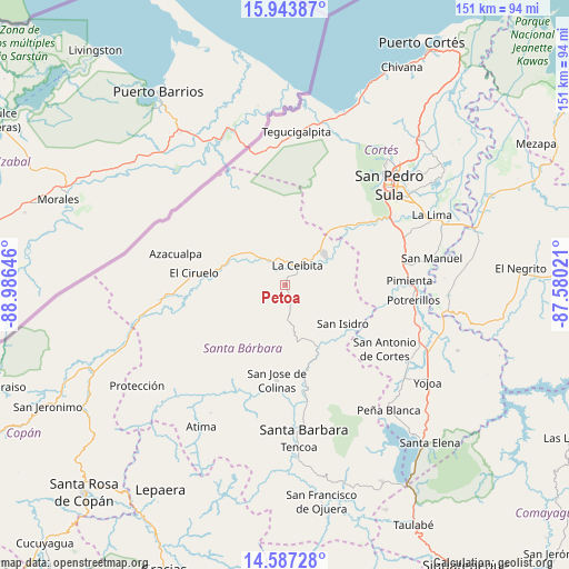
Petoa GPS coordinates[2]
15° 16' 0.012" North, 88° 16' 59.988" West
| Map corner | latitude | longitude |
|---|---|---|
| Upper-left | 15.94387°, | -88.98646° |
| Center: | 15.26667°, | -88.28333° |
| Lower-right: | 14.58728°, | -87.58021° |
| Map W x H: | 150.8×150.8 km | = 93.7×93.7mi |
| max Lat: | 16.45° ⇑29.2% North |
| Petoa: | 15.26667° |
| min Lat: | ⇓70.8% South 13.11667° |
| min Long | Petoa | max Long |
| -89.23333° | -88.28333° | -83.23333° |
| W 23%⇐ | ⇒77% E |
Elevation
Elevation of Petoa is 270 m = 886 ft, and this is 291.2 m = 955 ft below average elevation for this country.
| Max E: |
1811 m = 5942 ft | 66.6% |
| Avg. | 561.2 m = 1841 ft | |
| Petoa | 270 m = 886 ft | |
Min E: |
1 m = 3 ft | 33.4% |
See also: Honduras elevation on elevation.city.
Geographical zone
Petoa is located in North Torrid zone (between Equator and Tropic of Cancer). Distance of this Northern Tropic circle is 908.4 km =564.5 mi to North.| Distance of | km | miles | from Petoa |
|---|---|---|---|
| North Pole | 8309.6 | 5163.3 | to North |
| Arctic Circle | 5703.7 | 3544.1 | to North |
| Tropic Cancer | 908.4 | 564.5 | to North |
| Equator | 1697.5 | 1054.8 | to South |


Nearby cities:
15 places around Petoa: (largest is in red/bold)
• Camalote
9.1 km =5.7 mi,  324°
324°
• Cofradía
20.6 km =12.8 mi,  43°
43°
• Concepción del Norte
19.6 km =12.2 mi,  124°
124°
• La Esperanza
19.8 km =12.3 mi,  32°
32°
• La Flecha
21.5 km =13.4 mi,  274°
274°
• Laguna Verde
14.5 km =9 mi, 120°
• Naco
16.8 km =10.4 mi, 39°
• Pinalejo
18 km =11.2 mi, 316°
• Potrerillos
16.1 km =10 mi, 270°
• Quimistán
15.6 km =9.7 mi,  306°
306°
• San Luis
23 km =14.3 mi,  207°
207°
• San Marcos
14.8 km =9.2 mi,  284°
284°
• Santa Cruz Minas
11.3 km =7 mi,  350°
350°
• Santa Elena
20.7 km =12.9 mi,  51°
51°
• Trinidad
15.8 km =9.8 mi,  160°
160°
Sources, notices
• [Note1] Compared only with cities in Honduras existing in our database
• [Src1] Map data: © OpenStreetMap contributors (CC-BY-SA)
• [Src2] Other city data from geonames.org with taken over terms of usage.
• [Src3] Geographical zone / Annual Mean Temperature by Robert A. Rohde @ Wikipedia
