Pinalejo geodata
Pinalejo (Santa Bárbara) is a populated place; located in Honduras in America/Tegucigalpa (GMT-6) time zone. With population of 3,767 people, there are 85 cities with bigger population in this country. Compared to other cities in Honduras, 78% of cities are located further ↓South; 80.8% of cities are located further →East and 69.2% of cities have higher elevation than Pinalejo. Note1


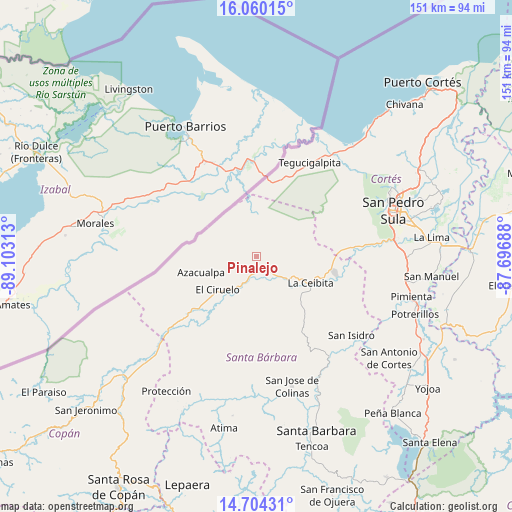
Pinalejo GPS coordinates[2]
15° 22' 59.988" North, 88° 24' 0" West
| Map corner | latitude | longitude |
|---|---|---|
| Upper-left | 16.06015°, | -89.10313° |
| Center: | 15.38333°, | -88.4° |
| Lower-right: | 14.70431°, | -87.69688° |
| Map W x H: | 150.8×150.8 km | = 93.7×93.7mi |
| max Lat: | 16.45° ⇑22% North |
| Pinalejo: | 15.38333° |
| min Lat: | ⇓78% South 13.11667° |
| min Long | Pinalejo | max Long |
| -89.23333° | -88.4° | -83.23333° |
| W 19.2%⇐ | ⇒80.8% E |
Elevation
Elevation of Pinalejo is 239 m = 784 ft, and this is 322.2 m = 1057 ft below average elevation for this country.
| Max E: |
1811 m = 5942 ft | 69.2% |
| Avg. | 561.2 m = 1841 ft | |
| Pinalejo | 239 m = 784 ft | |
Min E: |
1 m = 3 ft | 30.8% |
See also: Honduras elevation on elevation.city.
Geographical zone
Pinalejo is located in North Torrid zone (between Equator and Tropic of Cancer). Distance of this Northern Tropic circle is 895.5 km =556.4 mi to North.| Distance of | km | miles | from Pinalejo |
|---|---|---|---|
| North Pole | 8296.6 | 5155.3 | to North |
| Arctic Circle | 5690.7 | 3536 | to North |
| Tropic Cancer | 895.5 | 556.4 | to North |
| Equator | 1710.5 | 1062.9 | to South |


Nearby cities:
15 places around Pinalejo: (largest is in red/bold)
• Agualote
17.3 km =10.7 mi,  251°
251°
• Azacualpa
16.8 km =10.4 mi, 254°
• Camalote
9.1 km =5.7 mi,  127°
127°
• Casa Quemada
20.7 km =12.9 mi,  231°
231°
• Corinto
22.5 km =14 mi,  9°
9°
• Correderos
6.5 km =4 mi,  304°
304°
• El Ciruelo
14.2 km =8.8 mi, 229°
• La Flecha
14.3 km =8.9 mi,  218°
218°
• Loma Alta
17.2 km =10.7 mi,  274°
274°
• Naco
23.2 km =14.4 mi,  90°
90°
• Petoa
18 km =11.2 mi,  136°
136°
• Potrerillos
13.5 km =8.4 mi,  195°
195°
• Quimistán
3.7 km =2.3 mi,  180°
180°
• San Marcos
9.4 km =5.8 mi,  190°
190°
• Santa Cruz Minas
10.9 km =6.8 mi,  99°
99°
Sources, notices
• [Note1] Compared only with cities in Honduras existing in our database
• [Src1] Map data: © OpenStreetMap contributors (CC-BY-SA)
• [Src2] Other city data from geonames.org with taken over terms of usage.
• [Src3] Geographical zone / Annual Mean Temperature by Robert A. Rohde @ Wikipedia
