Pueblo Nuevo geodata
Pueblo Nuevo (Cortés) is a populated place; located in Honduras in America/Tegucigalpa (GMT-6) time zone. With population of 3,556 people, there are 93 cities with bigger population in this country. Compared to other cities in Honduras, 72% of cities are located further ↓South; 68.6% of cities are located further →East and 76.8% of cities have higher elevation than Pueblo Nuevo. Note1


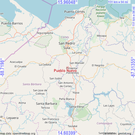
Pueblo Nuevo GPS coordinates[2]
15° 16' 59.988" North, 88° 1' 0.012" West
| Map corner | latitude | longitude |
|---|---|---|
| Upper-left | 15.96048°, | -88.7198° |
| Center: | 15.28333°, | -88.01667° |
| Lower-right: | 14.60399°, | -87.31355° |
| Map W x H: | 150.8×150.8 km | = 93.7×93.7mi |
| max Lat: | 16.45° ⇑28% North |
| Pueblo Nuevo: | 15.28333° |
| min Lat: | ⇓72% South 13.11667° |
| min Long | Pueblo Nuevo | max Long |
| -89.23333° | -88.01667° | -83.23333° |
| W 31.4%⇐ | ⇒68.6% E |
Elevation
Elevation of Pueblo Nuevo is 116 m = 381 ft, and this is 445.2 m = 1461 ft below average elevation for this country.
| Max E: |
1811 m = 5942 ft | 76.8% |
| Avg. | 561.2 m = 1841 ft | |
| Pueblo Nuevo | 116 m = 381 ft | |
Min E: |
1 m = 3 ft | 23.2% |
See also: Honduras elevation on elevation.city.
Geographical zone
Pueblo Nuevo is located in North Torrid zone (between Equator and Tropic of Cancer). Distance of this Northern Tropic circle is 906.6 km =563.3 mi to North.| Distance of | km | miles | from Pueblo Nuevo |
|---|---|---|---|
| North Pole | 8307.7 | 5162.2 | to North |
| Arctic Circle | 5701.8 | 3542.9 | to North |
| Tropic Cancer | 906.6 | 563.3 | to North |
| Equator | 1699.3 | 1055.9 | to South |


Nearby cities:
15 places around Pueblo Nuevo: (largest is in red/bold)
• Agua Blanca Sur
14.8 km =9.2 mi,  104°
104°
• Chotepe
15.3 km =9.5 mi,  13°
13°
• Concepción del Norte
18 km =11.2 mi,  223°
223°
• El Marañón
13.5 km =8.4 mi,  344°
344°
• El Milagro
14 km =8.7 mi,  22°
22°
• El Plan
5.4 km =3.4 mi,  90°
90°
• La Sabana
12.9 km =8 mi,  43°
43°
• Laguna Verde
18.6 km =11.6 mi,  240°
240°
• Nuevo Chamelecón
11.1 km =6.9 mi,  0°
0°
• Pimienta Vieja
7.7 km =4.8 mi,  136°
136°
• Potrerillos
7.7 km =4.8 mi, 136°
• San Antonio de Cortés
18.6 km =11.6 mi,  185°
185°
• San Manuel
12.1 km =7.5 mi,  62°
62°
• Santa Elena
16.7 km =10.4 mi,  311°
311°
• Villanueva
4.1 km =2.5 mi,  25°
25°
Sources, notices
• [Note1] Compared only with cities in Honduras existing in our database
• [Src1] Map data: © OpenStreetMap contributors (CC-BY-SA)
• [Src2] Other city data from geonames.org with taken over terms of usage.
• [Src3] Geographical zone / Annual Mean Temperature by Robert A. Rohde @ Wikipedia
