Concepción del Norte geodata
Concepción del Norte (Santa Bárbara) is a populated place; located in Honduras in America/Tegucigalpa (GMT-6) time zone. With population of 946 people, there are 455 cities with bigger population in this country. Compared to other cities in Honduras, 67.4% of cities are located further ↓South; 72.8% of cities are located further →East and 71.4% of cities have higher elevation than Concepción del Norte. Note1


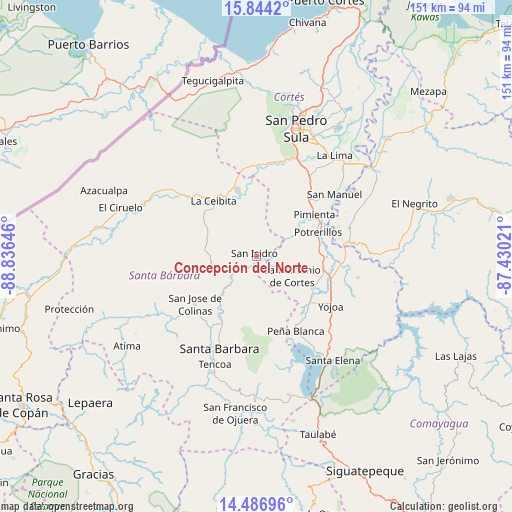
Concepción del Norte GPS coordinates[2]
15° 10' 0.012" North, 88° 7' 59.988" West
| Map corner | latitude | longitude |
|---|---|---|
| Upper-left | 15.8442°, | -88.83646° |
| Center: | 15.16667°, | -88.13333° |
| Lower-right: | 14.48696°, | -87.43021° |
| Map W x H: | 150.9×150.9 km | = 93.8×93.8mi |
| max Lat: | 16.45° ⇑32.6% North |
| Concepción del Norte: | 15.16667° |
| min Lat: | ⇓67.4% South 13.11667° |
| min Long | Concepción del | max Long |
| -89.23333° | -88.13333° | -83.23333° |
| W 27.2%⇐ | ⇒72.8% E |
Elevation
Elevation of Concepción del Norte is 204 m = 669 ft, and this is 357.2 m = 1172 ft below average elevation for this country.
| Max E: |
1811 m = 5942 ft | 71.4% |
| Avg. | 561.2 m = 1841 ft | |
| Concepción del Norte | 204 m = 669 ft | |
Min E: |
1 m = 3 ft | 28.6% |
See also: Honduras elevation on elevation.city.
Geographical zone
Concepción del Norte is located in North Torrid zone (between Equator and Tropic of Cancer). Distance of this Northern Tropic circle is 919.5 km =571.4 mi to North.| Distance of | km | miles | from Concepción del Norte |
|---|---|---|---|
| North Pole | 8320.7 | 5170.2 | to North |
| Arctic Circle | 5714.8 | 3551 | to North |
| Tropic Cancer | 919.5 | 571.4 | to North |
| Equator | 1686.4 | 1047.9 | to South |


Nearby cities:
15 places around Concepción del Norte: (largest is in red/bold)
• Bejuco
21.8 km =13.5 mi,  99°
99°
• Casa Quemada
7.7 km =4.8 mi,  136°
136°
• El Perico
9.9 km =6.2 mi,  158°
158°
• Guacamaya
16.8 km =10.4 mi,  186°
186°
• Ilama
14.3 km =8.9 mi,  218°
218°
• Laguna Verde
5.2 km =3.2 mi,  316°
316°
• Nueva Granada
6.6 km =4.1 mi,  147°
147°
• Petoa
19.6 km =12.2 mi,  304°
304°
• Pimienta Vieja
19.4 km =12.1 mi,  67°
67°
• Potrerillos
19.4 km =12.1 mi, 67°
• Pueblo Nuevo
18 km =11.2 mi,  43°
43°
• San Antonio de Cortés
12.1 km =7.5 mi,  117°
117°
• San José de Oriente
14.9 km =9.3 mi,  173°
173°
• San Luis de Planes
20.4 km =12.7 mi,  180°
180°
• Trinidad
11.4 km =7.1 mi,  250°
250°
Sources, notices
• [Note1] Compared only with cities in Honduras existing in our database
• [Src1] Map data: © OpenStreetMap contributors (CC-BY-SA)
• [Src2] Other city data from geonames.org with taken over terms of usage.
• [Src3] Geographical zone / Annual Mean Temperature by Robert A. Rohde @ Wikipedia
