Laguna Verde geodata
Laguna Verde (Santa Bárbara) is a populated place; located in Honduras in America/Tegucigalpa (GMT-6) time zone. With population of 1,460 people, there are 249 cities with bigger population in this country. Compared to other cities in Honduras, 68.2% of cities are located further ↓South; 73.8% of cities are located further →East and 75.8% of cities have lower elevation than Laguna Verde. Note1


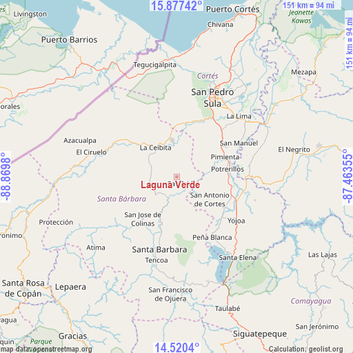
Laguna Verde GPS coordinates[2]
15° 12' 0" North, 88° 10' 0.012" West
| Map corner | latitude | longitude |
|---|---|---|
| Upper-left | 15.87742°, | -88.8698° |
| Center: | 15.2°, | -88.16667° |
| Lower-right: | 14.5204°, | -87.46355° |
| Map W x H: | 150.9×150.9 km | = 93.8×93.8mi |
| max Lat: | 16.45° ⇑31.8% North |
| Laguna Verde: | 15.2° |
| min Lat: | ⇓68.2% South 13.11667° |
| min Long | Laguna Verde | max Long |
| -89.23333° | -88.16667° | -83.23333° |
| W 26.2%⇐ | ⇒73.8% E |
Elevation
Elevation of Laguna Verde is 848 m = 2782 ft, and this is 286.8 m = 941 ft above average elevation for this country.
| Max E: |
1811 m = 5942 ft | 24.2% |
| Laguna Verde | 848 m 2782 ft | |
| Avg. | 561.2 m = 1841 ft | |
Min E: |
1 m = 3 ft | 75.8% |
See also: Honduras elevation on elevation.city.
Geographical zone
Laguna Verde is located in North Torrid zone (between Equator and Tropic of Cancer). Distance of this Northern Tropic circle is 915.8 km =569.1 mi to North.| Distance of | km | miles | from Laguna Verde |
|---|---|---|---|
| North Pole | 8317 | 5167.9 | to North |
| Arctic Circle | 5711.1 | 3548.7 | to North |
| Tropic Cancer | 915.8 | 569.1 | to North |
| Equator | 1690.1 | 1050.2 | to South |


Nearby cities:
15 places around Laguna Verde: (largest is in red/bold)
• Casa Quemada
12.9 km =8 mi,  136°
136°
• Concepción del Norte
5.2 km =3.2 mi, 136°
• El Perico
14.8 km =9.2 mi,  151°
151°
• Guacamaya
20.5 km =12.7 mi,  174°
174°
• Ilama
15.8 km =9.8 mi,  199°
199°
• Naco
20.5 km =12.7 mi,  354°
354°
• Nueva Granada
11.7 km =7.3 mi, 142°
• Petoa
14.5 km =9 mi,  300°
300°
• Pimienta Vieja
21.8 km =13.5 mi,  80°
80°
• Potrerillos
21.8 km =13.5 mi, 80°
• Pueblo Nuevo
18.6 km =11.6 mi,  60°
60°
• San Antonio de Cortés
17 km =10.6 mi,  122°
122°
• San José de Oriente
19.3 km =12 mi,  163°
163°
• Santa Elena
20.7 km =12.9 mi,  9°
9°
• Trinidad
10.3 km =6.4 mi,  223°
223°
Sources, notices
• [Note1] Compared only with cities in Honduras existing in our database
• [Src1] Map data: © OpenStreetMap contributors (CC-BY-SA)
• [Src2] Other city data from geonames.org with taken over terms of usage.
• [Src3] Geographical zone / Annual Mean Temperature by Robert A. Rohde @ Wikipedia
