Nuevo Chamelecón geodata
Nuevo Chamelecón (Cortés) is a populated place; located in Honduras in America/Tegucigalpa (GMT-6) time zone. With population of 2,098 people, there are 173 cities with bigger population in this country. Compared to other cities in Honduras, 78% of cities are located further ↓South; 68.6% of cities are located further →East and 63% of cities have higher elevation than Nuevo Chamelecón. Note1


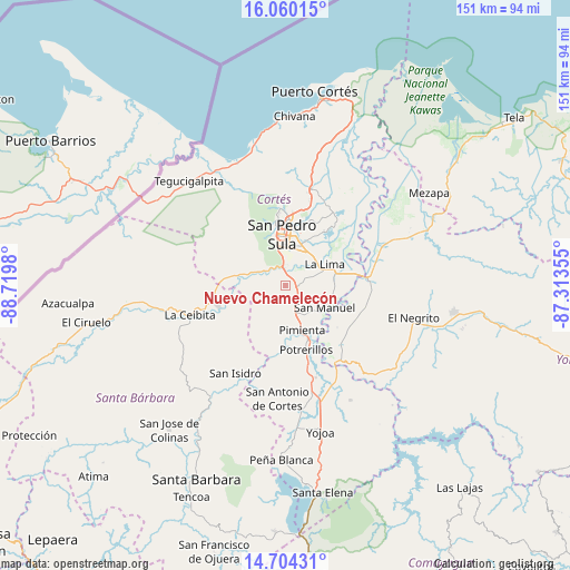
Nuevo Chamelecón GPS coordinates[2]
15° 22' 59.988" North, 88° 1' 0.012" West
| Map corner | latitude | longitude |
|---|---|---|
| Upper-left | 16.06015°, | -88.7198° |
| Center: | 15.38333°, | -88.01667° |
| Lower-right: | 14.70431°, | -87.31355° |
| Map W x H: | 150.8×150.8 km | = 93.7×93.7mi |
| max Lat: | 16.45° ⇑22% North |
| Nuevo Chamelecón: | 15.38333° |
| min Lat: | ⇓78% South 13.11667° |
| min Long | Nuevo Chamelec� | max Long |
| -89.23333° | -88.01667° | -83.23333° |
| W 31.4%⇐ | ⇒68.6% E |
Elevation
Elevation of Nuevo Chamelecón is 361 m = 1184 ft, and this is 200.2 m = 657 ft below average elevation for this country.
| Max E: |
1811 m = 5942 ft | 63% |
| Avg. | 561.2 m = 1841 ft | |
| Nuevo Chamelecón | 361 m = 1184 ft | |
Min E: |
1 m = 3 ft | 37% |
See also: Honduras elevation on elevation.city.
Geographical zone
Nuevo Chamelecón is located in North Torrid zone (between Equator and Tropic of Cancer). Distance of this Northern Tropic circle is 895.5 km =556.4 mi to North.| Distance of | km | miles | from Nuevo Chamelecón |
|---|---|---|---|
| North Pole | 8296.6 | 5155.3 | to North |
| Arctic Circle | 5690.7 | 3536 | to North |
| Tropic Cancer | 895.5 | 556.4 | to North |
| Equator | 1710.5 | 1062.9 | to South |


Nearby cities:
15 places around Nuevo Chamelecón: (largest is in red/bold)
• Armenta
13.5 km =8.4 mi,  344°
344°
• Chotepe
5.1 km =3.2 mi,  43°
43°
• Cofradía
14.4 km =8.9 mi,  277°
277°
• El Marañón
4 km =2.5 mi,  297°
297°
• El Milagro
5.7 km =3.5 mi,  70°
70°
• El Plan
12.3 km =7.6 mi,  154°
154°
• El Zapotal del Norte
15.3 km =9.5 mi,  346°
346°
• La Lima
12.1 km =7.5 mi,  62°
62°
• La Sabana
9.1 km =5.7 mi,  101°
101°
• Peña Blanca
17.1 km =10.6 mi, 347°
• Pueblo Nuevo
11.1 km =6.9 mi,  180°
180°
• San Manuel
12.1 km =7.5 mi,  117°
117°
• San Pedro Sula
13.5 km =8.4 mi,  356°
356°
• Santa Elena
12.5 km =7.8 mi,  270°
270°
• Villanueva
7.6 km =4.7 mi,  166°
166°
Sources, notices
• [Note1] Compared only with cities in Honduras existing in our database
• [Src1] Map data: © OpenStreetMap contributors (CC-BY-SA)
• [Src2] Other city data from geonames.org with taken over terms of usage.
• [Src3] Geographical zone / Annual Mean Temperature by Robert A. Rohde @ Wikipedia
