Comayagua geodata
Comayagua is a seat of a first-order administrative division; located in Honduras in America/Tegucigalpa (GMT-6) time zone. With population of 58,784 people, there are 6 cities with bigger population in this country. Compared to other cities in Honduras, 72.8% of cities are located further ↑North; 50.4% of cities are located further →East and 52.2% of cities have lower elevation than Comayagua. Note1


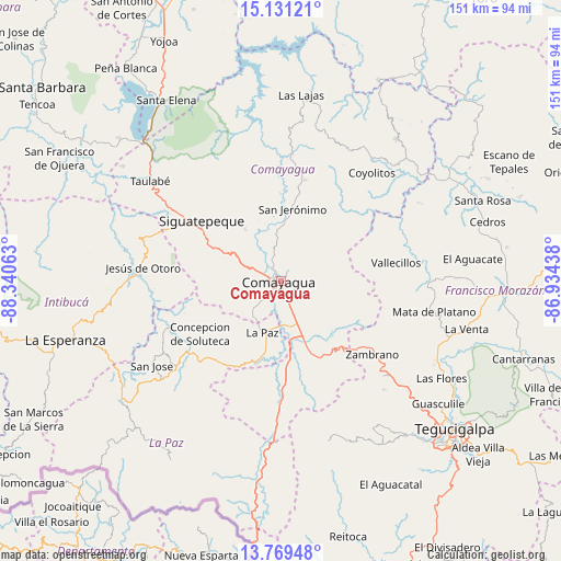
Comayagua GPS coordinates[2]
14° 27' 5.004" North, 87° 38' 15" West
| Map corner | latitude | longitude |
|---|---|---|
| Upper-left | 15.13121°, | -88.34063° |
| Center: | 14.45139°, | -87.6375° |
| Lower-right: | 13.76948°, | -86.93438° |
| Map W x H: | 151.4×151.4 km | = 94.1×94.1mi |
| max Lat: | 16.45° ⇑72.8% North |
| Comayagua: | 14.45139° |
| min Lat: | ⇓27.2% South 13.11667° |
| min Long | Comayagua | max Long |
| -89.23333° | -87.6375° | -83.23333° |
| W 49.6%⇐ | ⇒50.4% E |
Elevation
Elevation of Comayagua is 593 m = 1946 ft, and this is 31.8 m = 104 ft above average elevation for this country.
| Max E: |
1811 m = 5942 ft | 47.8% |
| Comayagua | 593 m 1946 ft | |
| Avg. | 561.2 m = 1841 ft | |
Min E: |
1 m = 3 ft | 52.2% |
See also: Comayagua elevation on elevation.city.
Geographical zone
Comayagua is located in North Torrid zone (between Equator and Tropic of Cancer). Distance of this Northern Tropic circle is 999.1 km =620.8 mi to North.| Distance of | km | miles | from Comayagua |
|---|---|---|---|
| North Pole | 8400.2 | 5219.6 | to North |
| Arctic Circle | 5794.3 | 3600.4 | to North |
| Tropic Cancer | 999.1 | 620.8 | to North |
| Equator | 1606.8 | 998.4 | to South |


Nearby cities:
15 places around Comayagua: (largest is in red/bold)
• Ajuterique
10.1 km =6.3 mi,  221°
221°
• Cane
18.9 km =11.7 mi,  189°
189°
• Concepción de Guasistagua
16.6 km =10.3 mi,  355°
355°
• El Sauce
9.1 km =5.7 mi,  340°
340°
• Flores
20.2 km =12.6 mi,  157°
157°
• La Paz
15.3 km =9.5 mi,  197°
197°
• Las Mercedes
20.2 km =12.6 mi, 157°
• Lejamaní
11.6 km =7.2 mi, 215°
• Palo Pintado
8.8 km =5.5 mi,  325°
325°
• San Antonio de la Cuesta
20.6 km =12.8 mi,  11°
11°
• San Jerónimo
20.6 km =12.8 mi, 11°
• Tepanguare
17.9 km =11.1 mi, 222°
• Valle de Ángeles
5.4 km =3.4 mi,  4°
4°
• Villa de San Antonio
15.1 km =9.4 mi,  171°
171°
• Yarumela
13.1 km =8.1 mi,  178°
178°
Sources, notices
• [Note1] Compared only with cities in Honduras existing in our database
• [Src1] Map data: © OpenStreetMap contributors (CC-BY-SA)
• [Src2] Other city data from geonames.org with taken over terms of usage.
• [Src3] Geographical zone / Annual Mean Temperature by Robert A. Rohde @ Wikipedia
