Morocelí geodata
Morocelí (El Paraíso) is a populated place; located in Honduras in America/Tegucigalpa (GMT-6) time zone. With population of 2,984 people, there are 113 cities with bigger population in this country. Compared to other cities in Honduras, 82.8% of cities are located further ↑North; 77.4% of cities are located further ←West and 54.2% of cities have lower elevation than Morocelí. Note1


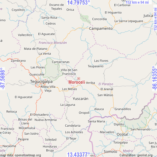
Morocelí GPS coordinates[2]
14° 7' 0.012" North, 86° 52' 0.012" West
| Map corner | latitude | longitude |
|---|---|---|
| Upper-left | 14.79753°, | -87.5698° |
| Center: | 14.11667°, | -86.86667° |
| Lower-right: | 13.43377°, | -86.16355° |
| Map W x H: | 151.6×151.6 km | = 94.2×94.2mi |
| max Lat: | 16.45° ⇑82.8% North |
| Morocelí: | 14.11667° |
| min Lat: | ⇓17.2% South 13.11667° |
| min Long | Morocelí | max Long |
| -89.23333° | -86.86667° | -83.23333° |
| W 77.4%⇐ | ⇒22.6% E |
Elevation
Elevation of Morocelí is 625 m = 2051 ft, and this is 63.8 m = 209 ft above average elevation for this country.
| Max E: |
1811 m = 5942 ft | 45.8% |
| Morocelí | 625 m 2051 ft | |
| Avg. | 561.2 m = 1841 ft | |
Min E: |
1 m = 3 ft | 54.2% |
See also: Honduras elevation on elevation.city.
Geographical zone
Morocelí is located in North Torrid zone (between Equator and Tropic of Cancer). Distance of this Northern Tropic circle is 1036.3 km =643.9 mi to North.| Distance of | km | miles | from Morocelí |
|---|---|---|---|
| North Pole | 8437.4 | 5242.8 | to North |
| Arctic Circle | 5831.5 | 3623.5 | to North |
| Tropic Cancer | 1036.3 | 643.9 | to North |
| Equator | 1569.6 | 975.3 | to South |


Nearby cities:
15 places around Morocelí: (largest is in red/bold)
• Danlí
31.9 km =19.8 mi,  106°
106°
• El Chimbo
27 km =16.8 mi,  273°
273°
• El Tablón
33.7 km =20.9 mi,  254°
254°
• El Terrero
22.3 km =13.9 mi,  255°
255°
• Güinope
26.9 km =16.7 mi,  195°
195°
• Jacaleapa
24.3 km =15.1 mi,  117°
117°
• San Juan de Flores
24.5 km =15.2 mi,  312°
312°
• San Juancito
24.3 km =15.1 mi,  297°
297°
• San Matías
29.2 km =18.1 mi, 120°
• Santa Lucía
27 km =16.8 mi, 266°
• Teupasenti
21.1 km =13.1 mi,  58°
58°
• Valle de Ángeles
18.3 km =11.4 mi,  281°
281°
• Villa Nueva
30.2 km =18.8 mi, 252°
• Villa de San Francisco
12.1 km =7.5 mi, 297°
• Yuscarán
19.3 km =12 mi,  175°
175°
Sources, notices
• [Note1] Compared only with cities in Honduras existing in our database
• [Src1] Map data: © OpenStreetMap contributors (CC-BY-SA)
• [Src2] Other city data from geonames.org with taken over terms of usage.
• [Src3] Geographical zone / Annual Mean Temperature by Robert A. Rohde @ Wikipedia
