Jacaleapa geodata
Jacaleapa (El Paraíso) is a populated place; located in Honduras in America/Tegucigalpa (GMT-6) time zone. With population of 2,578 people, there are 132 cities with bigger population in this country. Compared to other cities in Honduras, 87% of cities are located further ↑North; 81% of cities are located further ←West and 74.4% of cities have lower elevation than Jacaleapa. Note1


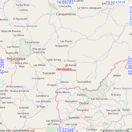
Jacaleapa GPS coordinates[2]
14° 1' 0.012" North, 86° 40' 0.012" West
| Map corner | latitude | longitude |
|---|---|---|
| Upper-left | 14.69783°, | -87.3698° |
| Center: | 14.01667°, | -86.66667° |
| Lower-right: | 13.33348°, | -85.96355° |
| Map W x H: | 151.7×151.7 km | = 94.3×94.3mi |
| max Lat: | 16.45° ⇑87% North |
| Jacaleapa: | 14.01667° |
| min Lat: | ⇓13% South 13.11667° |
| min Long | Jacaleapa | max Long |
| -89.23333° | -86.66667° | -83.23333° |
| W 81%⇐ | ⇒19% E |
Elevation
Elevation of Jacaleapa is 826 m = 2710 ft, and this is 264.8 m = 869 ft above average elevation for this country.
| Max E: |
1811 m = 5942 ft | 25.6% |
| Jacaleapa | 826 m 2710 ft | |
| Avg. | 561.2 m = 1841 ft | |
Min E: |
1 m = 3 ft | 74.4% |
See also: Honduras elevation on elevation.city.
Geographical zone
Jacaleapa is located in North Torrid zone (between Equator and Tropic of Cancer). Distance of this Northern Tropic circle is 1047.4 km =650.8 mi to North.| Distance of | km | miles | from Jacaleapa |
|---|---|---|---|
| North Pole | 8448.6 | 5249.7 | to North |
| Arctic Circle | 5842.7 | 3630.5 | to North |
| Tropic Cancer | 1047.4 | 650.8 | to North |
| Equator | 1558.5 | 968.4 | to South |


Nearby cities:
15 places around Jacaleapa: (largest is in red/bold)
• Araulí
14.6 km =9.1 mi,  120°
120°
• Cuyalí
19.5 km =12.1 mi,  139°
139°
• Danlí
9.2 km =5.7 mi,  78°
78°
• El Benque
21.7 km =13.5 mi,  85°
85°
• El Obraje
25.2 km =15.7 mi, 94°
• El Paraíso
20.9 km =13 mi, 142°
• El Pescadero
15.6 km =9.7 mi,  126°
126°
• Las Ánimas
28.1 km =17.5 mi,  22°
22°
• Morocelí
24.3 km =15.1 mi,  297°
297°
• Oropolí
27.5 km =17.1 mi,  216°
216°
• San Diego
21.9 km =13.6 mi, 80°
• San Matías
5.2 km =3.2 mi, 135°
• Santa Cruz
17.1 km =10.6 mi,  167°
167°
• Teupasenti
22.5 km =14 mi,  350°
350°
• Yuscarán
21.6 km =13.4 mi,  248°
248°
Sources, notices
• [Note1] Compared only with cities in Honduras existing in our database
• [Src1] Map data: © OpenStreetMap contributors (CC-BY-SA)
• [Src2] Other city data from geonames.org with taken over terms of usage.
• [Src3] Geographical zone / Annual Mean Temperature by Robert A. Rohde @ Wikipedia
