Yuscarán geodata
Yuscarán (El Paraíso) is a seat of a first-order administrative division; located in Honduras in America/Tegucigalpa (GMT-6) time zone. With population of 2,371 people, there are 148 cities with bigger population in this country. Compared to other cities in Honduras, 88.6% of cities are located further ↑North; 77.6% of cities are located further ←West and 81.4% of cities have lower elevation than Yuscarán. Note1


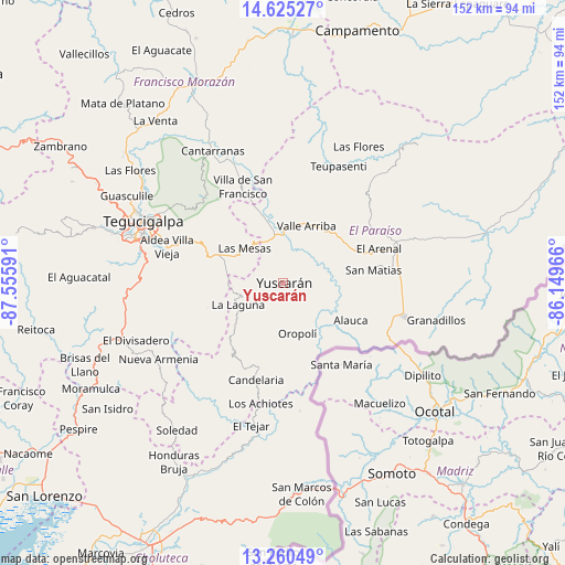
Yuscarán GPS coordinates[2]
13° 56' 38.004" North, 86° 51' 10.008" West
| Map corner | latitude | longitude |
|---|---|---|
| Upper-left | 14.62527°, | -87.55591° |
| Center: | 13.94389°, | -86.85278° |
| Lower-right: | 13.26049°, | -86.14966° |
| Map W x H: | 151.7×151.8 km | = 94.3×94.3mi |
| max Lat: | 16.45° ⇑88.6% North |
| Yuscarán: | 13.94389° |
| min Lat: | ⇓11.4% South 13.11667° |
| min Long | Yuscarán | max Long |
| -89.23333° | -86.85278° | -83.23333° |
| W 77.6%⇐ | ⇒22.4% E |
Elevation
Elevation of Yuscarán is 958 m = 3143 ft, and this is 396.8 m = 1302 ft above average elevation for this country.
| Max E: |
1811 m = 5942 ft | 18.6% |
| Yuscarán | 958 m 3143 ft | |
| Avg. | 561.2 m = 1841 ft | |
Min E: |
1 m = 3 ft | 81.4% |
See also: Honduras elevation on elevation.city.
Geographical zone
Yuscarán is located in North Torrid zone (between Equator and Tropic of Cancer). Distance of this Northern Tropic circle is 1055.5 km =655.9 mi to North.| Distance of | km | miles | from Yuscarán |
|---|---|---|---|
| North Pole | 8456.6 | 5254.7 | to North |
| Arctic Circle | 5850.8 | 3635.5 | to North |
| Tropic Cancer | 1055.5 | 655.9 | to North |
| Equator | 1550.4 | 963.4 | to South |


Nearby cities:
15 places around Yuscarán: (largest is in red/bold)
• Araulí
32.7 km =20.3 mi,  88°
88°
• Danlí
30.7 km =19.1 mi,  71°
71°
• El Pescadero
32.7 km =20.3 mi, 92°
• El Terrero
26.8 km =16.7 mi,  300°
300°
• Güinope
11 km =6.8 mi,  232°
232°
• Jacaleapa
21.6 km =13.4 mi, 68°
• Mandasta
24.4 km =15.2 mi,  196°
196°
• Morocelí
19.3 km =12 mi,  355°
355°
• Oropolí
14.7 km =9.1 mi,  164°
164°
• San Lucas
25.7 km =16 mi, 204°
• San Matías
24.1 km =15 mi,  79°
79°
• Santa Cruz
25.2 km =15.7 mi,  109°
109°
• Valle de Ángeles
30.1 km =18.7 mi,  319°
319°
• Villa Nueva
31.9 km =19.8 mi,  288°
288°
• Villa de San Francisco
27.6 km =17.1 mi,  333°
333°
Sources, notices
• [Note1] Compared only with cities in Honduras existing in our database
• [Src1] Map data: © OpenStreetMap contributors (CC-BY-SA)
• [Src2] Other city data from geonames.org with taken over terms of usage.
• [Src3] Geographical zone / Annual Mean Temperature by Robert A. Rohde @ Wikipedia
