La Encarnación geodata
La Encarnación (Ocotepeque) is a populated place; located in Honduras in America/Tegucigalpa (GMT-6) time zone. With population of 1,484 people, there are 242 cities with bigger population in this country. Compared to other cities in Honduras, 63.2% of cities are located further ↑North; 97.4% of cities are located further →East and 80.6% of cities have lower elevation than La Encarnación. Note1


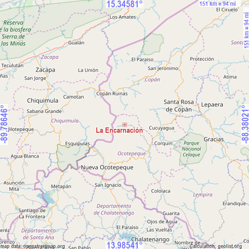
La Encarnación GPS coordinates[2]
14° 40' 0.012" North, 89° 4' 59.988" West
| Map corner | latitude | longitude |
|---|---|---|
| Upper-left | 15.34581°, | -89.78646° |
| Center: | 14.66667°, | -89.08333° |
| Lower-right: | 13.98541°, | -88.38021° |
| Map W x H: | 151.3×151.3 km | = 94×94mi |
| max Lat: | 16.45° ⇑63.2% North |
| La Encarnación: | 14.66667° |
| min Lat: | ⇓36.8% South 13.11667° |
| min Long | La Encarnación | max Long |
| -89.23333° | -89.08333° | -83.23333° |
| W 2.6%⇐ | ⇒97.4% E |
Elevation
Elevation of La Encarnación is 937 m = 3074 ft, and this is 375.8 m = 1233 ft above average elevation for this country.
| Max E: |
1811 m = 5942 ft | 19.4% |
| La Encarnación | 937 m 3074 ft | |
| Avg. | 561.2 m = 1841 ft | |
Min E: |
1 m = 3 ft | 80.6% |
See also: Honduras elevation on elevation.city.
Geographical zone
La Encarnación is located in North Torrid zone (between Equator and Tropic of Cancer). Distance of this Northern Tropic circle is 975.1 km =605.9 mi to North.| Distance of | km | miles | from La Encarnación |
|---|---|---|---|
| North Pole | 8376.3 | 5204.8 | to North |
| Arctic Circle | 5770.4 | 3585.6 | to North |
| Tropic Cancer | 975.1 | 605.9 | to North |
| Equator | 1630.8 | 1013.3 | to South |


Nearby cities:
15 places around La Encarnación: (largest is in red/bold)
• Copán
19.9 km =12.4 mi,  338°
338°
• Corquín
25.8 km =16 mi,  115°
115°
• Cucuyagua
23.4 km =14.5 mi,  94°
94°
• El Corpus
18.3 km =11.4 mi,  78°
78°
• La Labor
22.3 km =13.9 mi,  156°
156°
• Llano Largo
23.4 km =14.5 mi, 162°
• Los Arroyos
21.6 km =13.4 mi, 94°
• Lucerna
20.7 km =12.9 mi,  128°
128°
• Ostumán
20.6 km =12.8 mi,  334°
334°
• San Agustín
23.2 km =14.4 mi,  44°
44°
• San Antonio
20.9 km =13 mi,  143°
143°
• San Fernando
4 km =2.5 mi,  297°
297°
• Santa Cruz
14.2 km =8.8 mi,  49°
49°
• Santa Fe
23.2 km =14.4 mi,  224°
224°
• Santa Rita, Copan
22.4 km =13.9 mi,  355°
355°
Sources, notices
• [Note1] Compared only with cities in Honduras existing in our database
• [Src1] Map data: © OpenStreetMap contributors (CC-BY-SA)
• [Src2] Other city data from geonames.org with taken over terms of usage.
• [Src3] Geographical zone / Annual Mean Temperature by Robert A. Rohde @ Wikipedia
