Antigua Ocotepeque geodata
Antigua Ocotepeque (Ocotepeque) is a populated place; located in Honduras in America/Tegucigalpa (GMT-6) time zone. With population of 1,862 people, there are 197 cities with bigger population in this country. Compared to other cities in Honduras, 74.8% of cities are located further ↑North; 99.8% of cities are located further →East and 67.6% of cities have lower elevation than Antigua Ocotepeque. Note1


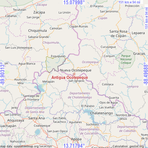
Antigua Ocotepeque GPS coordinates[2]
14° 24' 0" North, 89° 12' 0" West
| Map corner | latitude | longitude |
|---|---|---|
| Upper-left | 15.07998°, | -89.90313° |
| Center: | 14.4°, | -89.2° |
| Lower-right: | 13.71794°, | -88.49688° |
| Map W x H: | 151.4×151.4 km | = 94.1×94.1mi |
| max Lat: | 16.45° ⇑74.8% North |
| Antigua Ocotepeque: | 14.4° |
| min Lat: | ⇓25.2% South 13.11667° |
| min Long | Antigua Ocotepe | max Long |
| -89.23333° | -89.2° | -83.23333° |
| W 0.2%⇐ | ⇒99.8% E |
Elevation
Elevation of Antigua Ocotepeque is 751 m = 2464 ft, and this is 189.8 m = 623 ft above average elevation for this country.
| Max E: |
1811 m = 5942 ft | 32.4% |
| Antigua Ocotepeque | 751 m 2464 ft | |
| Avg. | 561.2 m = 1841 ft | |
Min E: |
1 m = 3 ft | 67.6% |
See also: Honduras elevation on elevation.city.
Geographical zone
Antigua Ocotepeque is located in North Torrid zone (between Equator and Tropic of Cancer). Distance of this Northern Tropic circle is 1004.8 km =624.4 mi to North.| Distance of | km | miles | from Antigua Ocotepeque |
|---|---|---|---|
| North Pole | 8405.9 | 5223.2 | to North |
| Arctic Circle | 5800 | 3604 | to North |
| Tropic Cancer | 1004.8 | 624.4 | to North |
| Equator | 1601.1 | 994.9 | to South |


Nearby cities:
15 places around Antigua Ocotepeque: (largest is in red/bold)
• El Tránsito
30.6 km =19 mi,  93°
93°
• La Encarnación
32.2 km =20 mi,  22°
22°
• La Labor
23.4 km =14.5 mi,  66°
66°
• Llano Largo
21.1 km =13.1 mi, 69°
• Mercedes
6.5 km =4 mi,  55°
55°
• Nueva Ocotepeque
4.1 km =2.5 mi,  25°
25°
• San Antonio
28.3 km =17.6 mi, 62°
• San Fernando
32.8 km =20.4 mi, 15°
• San Francisco del Valle
27.2 km =16.9 mi,  82°
82°
• San Marcos
26.9 km =16.7 mi, 90°
• Santa Fe
13.5 km =8.4 mi,  344°
344°
• Santa Lucía
1.9 km =1.2 mi,  0°
0°
• Santa Teresa
21.6 km =13.4 mi, 94°
• Sensenti
30.2 km =18.8 mi, 72°
• Sinuapa
5.8 km =3.6 mi, 17°
Sources, notices
• [Note1] Compared only with cities in Honduras existing in our database
• [Src1] Map data: © OpenStreetMap contributors (CC-BY-SA)
• [Src2] Other city data from geonames.org with taken over terms of usage.
• [Src3] Geographical zone / Annual Mean Temperature by Robert A. Rohde @ Wikipedia
