Liure geodata
Liure (El Paraíso) is a populated place; located in Honduras in America/Tegucigalpa (GMT-6) time zone. With population of 1,022 people, there are 409 cities with bigger population in this country. Compared to other cities in Honduras, 94.2% of cities are located further ↑North; 71.6% of cities are located further ←West and 70% of cities have higher elevation than Liure. Note1


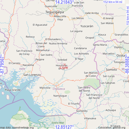
Liure GPS coordinates[2]
13° 32' 8.988" North, 87° 5' 30.984" West
| Map corner | latitude | longitude |
|---|---|---|
| Upper-left | 14.21843°, | -87.79507° |
| Center: | 13.53583°, | -87.09194° |
| Lower-right: | 12.85127°, | -86.38882° |
| Map W x H: | 152×152 km | = 94.4×94.4mi |
| max Lat: | 16.45° ⇑94.2% North |
| Liure: | 13.53583° |
| min Lat: | ⇓5.8% South 13.11667° |
| min Long | Liure | max Long |
| -89.23333° | -87.09194° | -83.23333° |
| W 71.6%⇐ | ⇒28.4% E |
Elevation
Elevation of Liure is 223 m = 732 ft, and this is 338.2 m = 1110 ft below average elevation for this country.
| Max E: |
1811 m = 5942 ft | 70% |
| Avg. | 561.2 m = 1841 ft | |
| Liure | 223 m = 732 ft | |
Min E: |
1 m = 3 ft | 30% |
See also: Honduras elevation on elevation.city.
Geographical zone
Liure is located in North Torrid zone (between Equator and Tropic of Cancer). Distance of this Northern Tropic circle is 1100.9 km =684.1 mi to North.| Distance of | km | miles | from Liure |
|---|---|---|---|
| North Pole | 8502 | 5282.9 | to North |
| Arctic Circle | 5896.1 | 3663.7 | to North |
| Tropic Cancer | 1100.9 | 684.1 | to North |
| Equator | 1505 | 935.2 | to South |


Nearby cities:
15 places around Liure: (largest is in red/bold)
• Agua Caliente de Linaca
18.8 km =11.7 mi,  233°
233°
• Ciudad Choluteca
28.3 km =17.6 mi,  202°
202°
• Corpus
28.1 km =17.5 mi,  167°
167°
• Duyure
31.7 km =19.7 mi,  69°
69°
• El Puente
28.2 km =17.5 mi,  185°
185°
• Mandasta
29 km =18 mi,  40°
40°
• Morolica
21 km =13 mi,  80°
80°
• Orocuina
6.2 km =3.9 mi, 193°
• Pespire
29.8 km =18.5 mi,  282°
282°
• Sabanagrande
35.2 km =21.9 mi,  329°
329°
• San Francisco
28 km =17.4 mi,  132°
132°
• San Lucas
26.8 km =16.7 mi,  34°
34°
• San Marcos de Colón
33.6 km =20.9 mi,  109°
109°
• Santa Ana de Yusguare
26.3 km =16.3 mi, 185°
• Texíguat
14.7 km =9.1 mi, 30°
Sources, notices
• [Note1] Compared only with cities in Honduras existing in our database
• [Src1] Map data: © OpenStreetMap contributors (CC-BY-SA)
• [Src2] Other city data from geonames.org with taken over terms of usage.
• [Src3] Geographical zone / Annual Mean Temperature by Robert A. Rohde @ Wikipedia
