El Puente geodata
El Puente (Choluteca) is a populated place; located in Honduras in America/Tegucigalpa (GMT-6) time zone. With population of 1,325 people, there are 282 cities with bigger population in this country. Compared to other cities in Honduras, 98.2% of cities are located further ↑North; 69.4% of cities are located further ←West and 69% of cities have higher elevation than El Puente. Note1


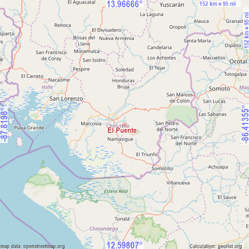
El Puente GPS coordinates[2]
13° 16' 59.988" North, 87° 7' 0.012" West
| Map corner | latitude | longitude |
|---|---|---|
| Upper-left | 13.96666°, | -87.8198° |
| Center: | 13.28333°, | -87.11667° |
| Lower-right: | 12.59807°, | -86.41355° |
| Map W x H: | 152.2×152.2 km | = 94.6×94.6mi |
| max Lat: | 16.45° ⇑98.2% North |
| El Puente: | 13.28333° |
| min Lat: | ⇓1.8% South 13.11667° |
| min Long | El Puente | max Long |
| -89.23333° | -87.11667° | -83.23333° |
| W 69.4%⇐ | ⇒30.6% E |
Elevation
Elevation of El Puente is 243 m = 797 ft, and this is 318.2 m = 1044 ft below average elevation for this country.
| Max E: |
1811 m = 5942 ft | 69% |
| Avg. | 561.2 m = 1841 ft | |
| El Puente | 243 m = 797 ft | |
Min E: |
1 m = 3 ft | 31% |
See also: Honduras elevation on elevation.city.
Geographical zone
El Puente is located in North Torrid zone (between Equator and Tropic of Cancer). Distance of this Northern Tropic circle is 1129 km =701.5 mi to North.| Distance of | km | miles | from El Puente |
|---|---|---|---|
| North Pole | 8530.1 | 5300.4 | to North |
| Arctic Circle | 5924.2 | 3681.1 | to North |
| Tropic Cancer | 1129 | 701.5 | to North |
| Equator | 1477 | 917.8 | to South |


Nearby cities:
15 places around El Puente: (largest is in red/bold)
• Agua Caliente de Linaca
21 km =13 mi,  323°
323°
• Ciudad Choluteca
8.2 km =5.1 mi,  283°
283°
• Concepción de María
14.6 km =9.1 mi,  120°
120°
• Corpus
8.9 km =5.5 mi,  86°
86°
• El Obraje
14.4 km =8.9 mi,  186°
186°
• El Perico
18.5 km =11.5 mi,  150°
150°
• El Triunfo
22.4 km =13.9 mi, 145°
• Los Llanitos
23.6 km =14.7 mi,  270°
270°
• Marcovia
20.9 km =13 mi, 271°
• Namasigüe
9.1 km =5.7 mi,  195°
195°
• Orocuina
22.1 km =13.7 mi,  3°
3°
• San Agustín
9.3 km =5.8 mi,  180°
180°
• San Francisco
25.2 km =15.7 mi,  68°
68°
• San Jerónimo
12.1 km =7.5 mi, 190°
• Santa Ana de Yusguare
1.9 km =1.2 mi,  8°
8°
Sources, notices
• [Note1] Compared only with cities in Honduras existing in our database
• [Src1] Map data: © OpenStreetMap contributors (CC-BY-SA)
• [Src2] Other city data from geonames.org with taken over terms of usage.
• [Src3] Geographical zone / Annual Mean Temperature by Robert A. Rohde @ Wikipedia
