Morolica geodata
Morolica (Choluteca) is a populated place; located in Honduras in America/Tegucigalpa (GMT-6) time zone. With population of 973 people, there are 433 cities with bigger population in this country. Compared to other cities in Honduras, 93.8% of cities are located further ↑North; 77% of cities are located further ←West and 72.8% of cities have higher elevation than Morolica. Note1


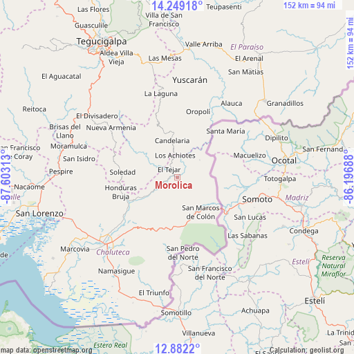
Morolica GPS coordinates[2]
13° 34' 0.012" North, 86° 54' 0" West
| Map corner | latitude | longitude |
|---|---|---|
| Upper-left | 14.24918°, | -87.60313° |
| Center: | 13.56667°, | -86.9° |
| Lower-right: | 12.8822°, | -86.19688° |
| Map W x H: | 152×152 km | = 94.4×94.4mi |
| max Lat: | 16.45° ⇑93.8% North |
| Morolica: | 13.56667° |
| min Lat: | ⇓6.2% South 13.11667° |
| min Long | Morolica | max Long |
| -89.23333° | -86.9° | -83.23333° |
| W 77%⇐ | ⇒23% E |
Elevation
Elevation of Morolica is 189 m = 620 ft, and this is 372.2 m = 1221 ft below average elevation for this country.
| Max E: |
1811 m = 5942 ft | 72.8% |
| Avg. | 561.2 m = 1841 ft | |
| Morolica | 189 m = 620 ft | |
Min E: |
1 m = 3 ft | 27.2% |
See also: Honduras elevation on elevation.city.
Geographical zone
Morolica is located in North Torrid zone (between Equator and Tropic of Cancer). Distance of this Northern Tropic circle is 1097.4 km =681.9 mi to North.| Distance of | km | miles | from Morolica |
|---|---|---|---|
| North Pole | 8498.6 | 5280.8 | to North |
| Arctic Circle | 5892.7 | 3661.6 | to North |
| Tropic Cancer | 1097.4 | 681.9 | to North |
| Equator | 1508.5 | 937.3 | to South |


Nearby cities:
15 places around Morolica: (largest is in red/bold)
• Agua Caliente de Linaca
38.7 km =24 mi,  247°
247°
• Concepción de María
40.4 km =25.1 mi,  195°
195°
• Corpus
34.2 km =21.3 mi,  205°
205°
• Duyure
11.7 km =7.3 mi,  50°
50°
• El Puente
39.3 km =24.4 mi,  216°
216°
• Güinope
35.4 km =22 mi,  354°
354°
• Liure
21 km =13 mi,  260°
260°
• Mandasta
18.6 km =11.6 mi, 354°
• Orocuina
24.1 km =15 mi, 246°
• Oropolí
29.2 km =18.1 mi,  17°
17°
• San Francisco
22.2 km =13.8 mi,  180°
180°
• San Lucas
19.3 km =12 mi,  343°
343°
• San Marcos de Colón
18.3 km =11.4 mi,  143°
143°
• Santa Ana de Yusguare
37.6 km =23.4 mi, 218°
• Texíguat
16.1 km =10 mi,  304°
304°
Sources, notices
• [Note1] Compared only with cities in Honduras existing in our database
• [Src1] Map data: © OpenStreetMap contributors (CC-BY-SA)
• [Src2] Other city data from geonames.org with taken over terms of usage.
• [Src3] Geographical zone / Annual Mean Temperature by Robert A. Rohde @ Wikipedia
