San Lucas geodata
San Lucas (El Paraíso) is a populated place; located in Honduras in America/Tegucigalpa (GMT-6) time zone. With population of 1,307 people, there are 289 cities with bigger population in this country. Compared to other cities in Honduras, 92.4% of cities are located further ↑North; 75.8% of cities are located further ←West and 94.6% of cities have lower elevation than San Lucas. Note1


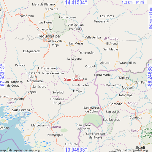
San Lucas GPS coordinates[2]
13° 43' 59.988" North, 86° 57' 0" West
| Map corner | latitude | longitude |
|---|---|---|
| Upper-left | 14.41534°, | -87.65313° |
| Center: | 13.73333°, | -86.95° |
| Lower-right: | 13.04933°, | -86.24688° |
| Map W x H: | 151.9×151.9 km | = 94.4×94.4mi |
| max Lat: | 16.45° ⇑92.4% North |
| San Lucas: | 13.73333° |
| min Lat: | ⇓7.6% South 13.11667° |
| min Long | San Lucas | max Long |
| -89.23333° | -86.95° | -83.23333° |
| W 75.8%⇐ | ⇒24.2% E |
Elevation
Elevation of San Lucas is 1290 m = 4232 ft, and this is 728.8 m = 2391 ft above average elevation for this country.
| Max E: |
1811 m = 5942 ft | 5.4% |
| San Lucas | 1290 m 4232 ft | |
| Avg. | 561.2 m = 1841 ft | |
Min E: |
1 m = 3 ft | 94.6% |
See also: Honduras elevation on elevation.city.
Geographical zone
San Lucas is located in North Torrid zone (between Equator and Tropic of Cancer). Distance of this Northern Tropic circle is 1078.9 km =670.4 mi to North.| Distance of | km | miles | from San Lucas |
|---|---|---|---|
| North Pole | 8480.1 | 5269.3 | to North |
| Arctic Circle | 5874.2 | 3650.1 | to North |
| Tropic Cancer | 1078.9 | 670.4 | to North |
| Equator | 1527 | 948.8 | to South |


Nearby cities:
15 places around San Lucas: (largest is in red/bold)
• Cerro Grande
33.7 km =20.9 mi,  285°
285°
• Duyure
18.2 km =11.3 mi,  127°
127°
• El Terrero
39.1 km =24.3 mi,  341°
341°
• Güinope
16.8 km =10.4 mi,  6°
6°
• Liure
26.8 km =16.7 mi,  214°
214°
• Mandasta
3.6 km =2.2 mi,  90°
90°
• Morolica
19.3 km =12 mi,  163°
163°
• Orocuina
32.6 km =20.3 mi, 210°
• Oropolí
17.1 km =10.6 mi,  57°
57°
• Sabanagrande
34.4 km =21.4 mi,  283°
283°
• San Marcos de Colón
37.1 km =23.1 mi,  154°
154°
• Santa Cruz
37.3 km =23.2 mi,  66°
66°
• Texíguat
12.2 km =7.6 mi,  220°
220°
• Villa Nueva
38.8 km =24.1 mi,  329°
329°
• Yuscarán
25.7 km =16 mi,  24°
24°
Sources, notices
• [Note1] Compared only with cities in Honduras existing in our database
• [Src1] Map data: © OpenStreetMap contributors (CC-BY-SA)
• [Src2] Other city data from geonames.org with taken over terms of usage.
• [Src3] Geographical zone / Annual Mean Temperature by Robert A. Rohde @ Wikipedia
