La Guacamaya geodata
La Guacamaya (Yoro) is a populated place; located in Honduras in America/Tegucigalpa (GMT-6) time zone. With population of 2,525 people, there are 136 cities with bigger population in this country. Compared to other cities in Honduras, 70% of cities are located further ↓South; 56% of cities are located further →East and 95.8% of cities have lower elevation than La Guacamaya. Note1


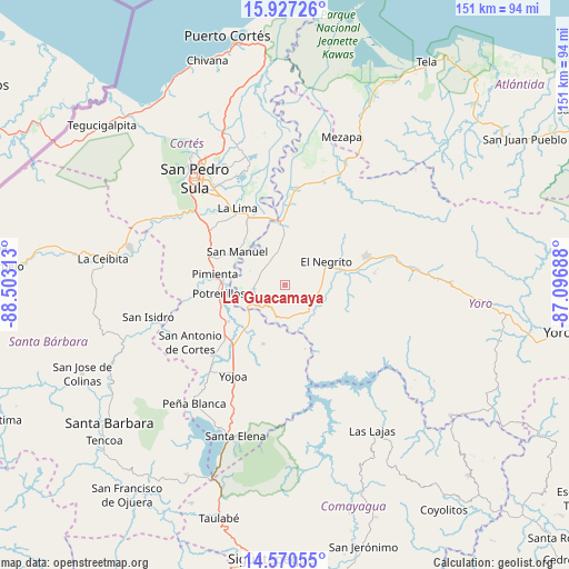
La Guacamaya GPS coordinates[2]
15° 15' 0" North, 87° 48' 0" West
| Map corner | latitude | longitude |
|---|---|---|
| Upper-left | 15.92726°, | -88.50313° |
| Center: | 15.25°, | -87.8° |
| Lower-right: | 14.57055°, | -87.09688° |
| Map W x H: | 150.9×150.9 km | = 93.8×93.8mi |
| max Lat: | 16.45° ⇑30% North |
| La Guacamaya: | 15.25° |
| min Lat: | ⇓70% South 13.11667° |
| min Long | La Guacamaya | max Long |
| -89.23333° | -87.8° | -83.23333° |
| W 44%⇐ | ⇒56% E |
Elevation
Elevation of La Guacamaya is 1356 m = 4449 ft, and this is 794.8 m = 2608 ft above average elevation for this country.
| Max E: |
1811 m = 5942 ft | 4.2% |
| La Guacamaya | 1356 m 4449 ft | |
| Avg. | 561.2 m = 1841 ft | |
Min E: |
1 m = 3 ft | 95.8% |
See also: Honduras elevation on elevation.city.
Geographical zone
La Guacamaya is located in North Torrid zone (between Equator and Tropic of Cancer). Distance of this Northern Tropic circle is 910.3 km =565.6 mi to North.| Distance of | km | miles | from La Guacamaya |
|---|---|---|---|
| North Pole | 8311.4 | 5164.5 | to North |
| Arctic Circle | 5705.5 | 3545.2 | to North |
| Tropic Cancer | 910.3 | 565.6 | to North |
| Equator | 1695.6 | 1053.6 | to South |


Nearby cities:
15 places around La Guacamaya: (largest is in red/bold)
• Agua Blanca Sur
8.9 km =5.5 mi,  270°
270°
• Bejuco
19.3 km =12 mi,  227°
227°
• El Llano
14.3 km =8.9 mi,  218°
218°
• El Negrito
13 km =8.1 mi,  55°
55°
• El Olivar
20.6 km =12.8 mi,  205°
205°
• El Plan
18.3 km =11.4 mi,  281°
281°
• El Progreso
16.7 km =10.4 mi,  0°
0°
• La Mina
8.2 km =5.1 mi,  334°
334°
• La Sabana
19.3 km =12 mi,  312°
312°
• La Sarrosa
4 km =2.5 mi,  242°
242°
• Nueva Esperanza
21.5 km =13.4 mi,  85°
85°
• Pimienta Vieja
18 km =11.2 mi,  264°
264°
• Potrerillos
18 km =11.2 mi, 264°
• Quebrada de Yoro
20.5 km =12.7 mi,  5°
5°
• San Manuel
15.6 km =9.7 mi, 306°
Sources, notices
• [Note1] Compared only with cities in Honduras existing in our database
• [Src1] Map data: © OpenStreetMap contributors (CC-BY-SA)
• [Src2] Other city data from geonames.org with taken over terms of usage.
• [Src3] Geographical zone / Annual Mean Temperature by Robert A. Rohde @ Wikipedia
