La Sarrosa geodata
La Sarrosa (Yoro) is a populated place; located in Honduras in America/Tegucigalpa (GMT-6) time zone. With population of 2,188 people, there are 165 cities with bigger population in this country. Compared to other cities in Honduras, 69% of cities are located further ↓South; 57% of cities are located further →East and 59% of cities have lower elevation than La Sarrosa. Note1


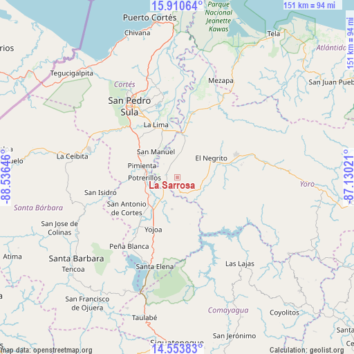
La Sarrosa GPS coordinates[2]
15° 13' 59.988" North, 87° 49' 59.988" West
| Map corner | latitude | longitude |
|---|---|---|
| Upper-left | 15.91064°, | -88.53646° |
| Center: | 15.23333°, | -87.83333° |
| Lower-right: | 14.55383°, | -87.13021° |
| Map W x H: | 150.9×150.9 km | = 93.8×93.8mi |
| max Lat: | 16.45° ⇑31% North |
| La Sarrosa: | 15.23333° |
| min Lat: | ⇓69% South 13.11667° |
| min Long | La Sarrosa | max Long |
| -89.23333° | -87.83333° | -83.23333° |
| W 43%⇐ | ⇒57% E |
Elevation
Elevation of La Sarrosa is 666 m = 2185 ft, and this is 104.8 m = 344 ft above average elevation for this country.
| Max E: |
1811 m = 5942 ft | 41% |
| La Sarrosa | 666 m 2185 ft | |
| Avg. | 561.2 m = 1841 ft | |
Min E: |
1 m = 3 ft | 59% |
See also: Honduras elevation on elevation.city.
Geographical zone
La Sarrosa is located in North Torrid zone (between Equator and Tropic of Cancer). Distance of this Northern Tropic circle is 912.1 km =566.8 mi to North.| Distance of | km | miles | from La Sarrosa |
|---|---|---|---|
| North Pole | 8313.3 | 5165.6 | to North |
| Arctic Circle | 5707.4 | 3546.4 | to North |
| Tropic Cancer | 912.1 | 566.8 | to North |
| Equator | 1693.8 | 1052.5 | to South |


Nearby cities:
15 places around La Sarrosa: (largest is in red/bold)
• Agua Blanca Sur
5.7 km =3.5 mi,  289°
289°
• Bejuco
15.5 km =9.6 mi,  223°
223°
• El Llano
10.7 km =6.6 mi,  210°
210°
• El Negrito
17 km =10.6 mi,  57°
57°
• El Olivar
17.5 km =10.9 mi,  197°
197°
• El Plan
15.3 km =9.5 mi, 291°
• El Progreso
18.9 km =11.7 mi,  10°
10°
• La Guacamaya
4 km =2.5 mi, 62°
• La Mina
9.3 km =5.8 mi,  0°
0°
• La Sabana
18.3 km =11.4 mi,  324°
324°
• Pimienta Vieja
14.3 km =8.9 mi,  270°
270°
• Potrerillos
14.3 km =8.9 mi, 270°
• Pueblo Nuevo
20.4 km =12.7 mi, 285°
• San Manuel
14.3 km =8.9 mi, 321°
• Villanueva
20.1 km =12.5 mi,  297°
297°
Sources, notices
• [Note1] Compared only with cities in Honduras existing in our database
• [Src1] Map data: © OpenStreetMap contributors (CC-BY-SA)
• [Src2] Other city data from geonames.org with taken over terms of usage.
• [Src3] Geographical zone / Annual Mean Temperature by Robert A. Rohde @ Wikipedia
