El Progreso geodata
El Progreso (Yoro) is a populated place; located in Honduras in America/Tegucigalpa (GMT-6) time zone. With population of 100,810 people, there are 4 cities with bigger population in this country. Compared to other cities in Honduras, 79% of cities are located further ↓South; 56% of cities are located further →East and 84.2% of cities have higher elevation than El Progreso. Note1


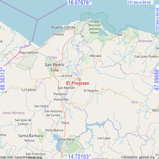
El Progreso GPS coordinates[2]
15° 24' 0" North, 87° 48' 0" West
| Map corner | latitude | longitude |
|---|---|---|
| Upper-left | 16.07676°, | -88.50313° |
| Center: | 15.4°, | -87.8° |
| Lower-right: | 14.72103°, | -87.09688° |
| Map W x H: | 150.7×150.7 km | = 93.6×93.6mi |
| max Lat: | 16.45° ⇑21% North |
| El Progreso: | 15.4° |
| min Lat: | ⇓79% South 13.11667° |
| min Long | El Progreso | max Long |
| -89.23333° | -87.8° | -83.23333° |
| W 44%⇐ | ⇒56% E |
Elevation
Elevation of El Progreso is 48 m = 157 ft, and this is 513.2 m = 1684 ft below average elevation for this country.
| Max E: |
1811 m = 5942 ft | 84.2% |
| Avg. | 561.2 m = 1841 ft | |
| El Progreso | 48 m = 157 ft | |
Min E: |
1 m = 3 ft | 15.8% |
See also: El Progreso elevation on elevation.city.
Geographical zone
El Progreso is located in North Torrid zone (between Equator and Tropic of Cancer). Distance of this Northern Tropic circle is 893.6 km =555.3 mi to North.| Distance of | km | miles | from El Progreso |
|---|---|---|---|
| North Pole | 8294.7 | 5154.1 | to North |
| Arctic Circle | 5688.9 | 3534.9 | to North |
| Tropic Cancer | 893.6 | 555.3 | to North |
| Equator | 1712.3 | 1064 | to South |


Nearby cities:
15 places around El Progreso: (largest is in red/bold)
• Agua Blanca Sur
18.9 km =11.7 mi,  208°
208°
• Chotepe
19.7 km =12.2 mi,  275°
275°
• El Milagro
17.9 km =11.1 mi,  270°
270°
• El Negrito
14.2 km =8.8 mi,  130°
130°
• Guaimitas
14.3 km =8.9 mi,  38°
38°
• La Guacamaya
16.7 km =10.4 mi,  180°
180°
• La Lima
13 km =8.1 mi,  286°
286°
• La Mina
9.9 km =6.2 mi,  201°
201°
• La Sabana
14.8 km =9.2 mi,  255°
255°
• La Sarrosa
18.9 km =11.7 mi,  190°
190°
• Ocote Paulino
21.5 km =13.4 mi,  85°
85°
• Quebrada de Yoro
4.1 km =2.5 mi,  25°
25°
• San José del Boquerón
11.7 km =7.3 mi,  322°
322°
• San Manuel
14.5 km =9 mi,  239°
239°
• Victoria
11.9 km =7.4 mi,  346°
346°
Sources, notices
• [Note1] Compared only with cities in Honduras existing in our database
• [Src1] Map data: © OpenStreetMap contributors (CC-BY-SA)
• [Src2] Other city data from geonames.org with taken over terms of usage.
• [Src3] Geographical zone / Annual Mean Temperature by Robert A. Rohde @ Wikipedia
