El Negrito geodata
El Negrito (Yoro) is a populated place; located in Honduras in America/Tegucigalpa (GMT-6) time zone. With population of 9,303 people, there are 35 cities with bigger population in this country. Compared to other cities in Honduras, 74% of cities are located further ↓South; 53.2% of cities are located further →East and 69.4% of cities have higher elevation than El Negrito. Note1


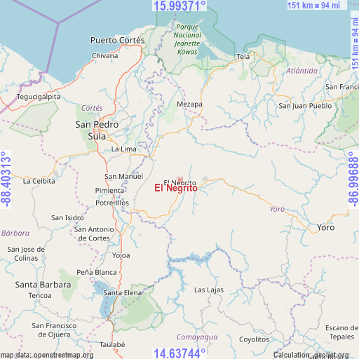
El Negrito GPS coordinates[2]
15° 19' 0.012" North, 87° 42' 0" West
| Map corner | latitude | longitude |
|---|---|---|
| Upper-left | 15.99371°, | -88.40313° |
| Center: | 15.31667°, | -87.7° |
| Lower-right: | 14.63744°, | -86.99688° |
| Map W x H: | 150.8×150.8 km | = 93.7×93.7mi |
| max Lat: | 16.45° ⇑26% North |
| El Negrito: | 15.31667° |
| min Lat: | ⇓74% South 13.11667° |
| min Long | El Negrito | max Long |
| -89.23333° | -87.7° | -83.23333° |
| W 46.8%⇐ | ⇒53.2% E |
Elevation
Elevation of El Negrito is 231 m = 758 ft, and this is 330.2 m = 1083 ft below average elevation for this country.
| Max E: |
1811 m = 5942 ft | 69.4% |
| Avg. | 561.2 m = 1841 ft | |
| El Negrito | 231 m = 758 ft | |
Min E: |
1 m = 3 ft | 30.6% |
See also: Honduras elevation on elevation.city.
Geographical zone
El Negrito is located in North Torrid zone (between Equator and Tropic of Cancer). Distance of this Northern Tropic circle is 902.9 km =561 mi to North.| Distance of | km | miles | from El Negrito |
|---|---|---|---|
| North Pole | 8304 | 5159.9 | to North |
| Arctic Circle | 5698.1 | 3540.6 | to North |
| Tropic Cancer | 902.9 | 561 | to North |
| Equator | 1703.1 | 1058.3 | to South |


Nearby cities:
15 places around El Negrito: (largest is in red/bold)
• Agua Blanca Sur
21 km =13 mi,  249°
249°
• El Portillo de González
11.3 km =7 mi,  109°
109°
• El Progreso
14.2 km =8.8 mi,  310°
310°
• Guaimitas
20.5 km =12.7 mi,  354°
354°
• La Estancia
16.5 km =10.3 mi,  102°
102°
• La Guacamaya
13 km =8.1 mi,  235°
235°
• La Mina
14.3 km =8.9 mi,  270°
270°
• La Sarrosa
17 km =10.6 mi, 237°
• Mojimán
12.1 km =7.5 mi,  117°
117°
• Morazán
10.7 km =6.6 mi,  90°
90°
• Nueva Esperanza
12.1 km =7.5 mi, 117°
• Ocote Paulino
15.4 km =9.6 mi,  43°
43°
• Quebrada de Yoro
15.8 km =9.8 mi,  325°
325°
• San Manuel
23.3 km =14.5 mi, 274°
• Victoria
24.8 km =15.4 mi, 326°
Sources, notices
• [Note1] Compared only with cities in Honduras existing in our database
• [Src1] Map data: © OpenStreetMap contributors (CC-BY-SA)
• [Src2] Other city data from geonames.org with taken over terms of usage.
• [Src3] Geographical zone / Annual Mean Temperature by Robert A. Rohde @ Wikipedia
