La Ceiba geodata
La Ceiba (Atlántida) is a seat of a first-order administrative division; located in Honduras in America/Tegucigalpa (GMT-6) time zone. With population of 130,218 people, there are 3 cities with bigger population in this country. Compared to other cities in Honduras, 94.2% of cities are located further ↓South; 79.4% of cities are located further ←West and 93.4% of cities have higher elevation than La Ceiba. Note1


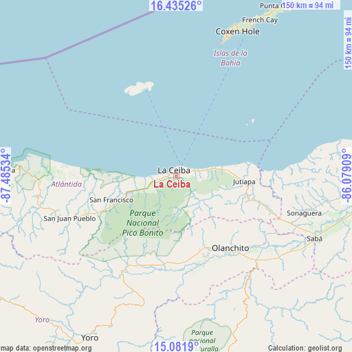
La Ceiba GPS coordinates[2]
15° 45' 34.956" North, 86° 46' 55.956" West
| Map corner | latitude | longitude |
|---|---|---|
| Upper-left | 16.43526°, | -87.48534° |
| Center: | 15.75971°, | -86.78221° |
| Lower-right: | 15.0819°, | -86.07909° |
| Map W x H: | 150.5×150.5 km | = 93.5×93.5mi |
| max Lat: | 16.45° ⇑5.8% North |
| La Ceiba: | 15.75971° |
| min Lat: | ⇓94.2% South 13.11667° |
| min Long | La Ceiba | max Long |
| -89.23333° | -86.78221° | -83.23333° |
| W 79.4%⇐ | ⇒20.6% E |
Elevation
Elevation of La Ceiba is 14 m = 46 ft, and this is 547.2 m = 1795 ft below average elevation for this country.
| Max E: |
1811 m = 5942 ft | 93.4% |
| Avg. | 561.2 m = 1841 ft | |
| La Ceiba | 14 m = 46 ft | |
Min E: |
1 m = 3 ft | 6.6% |
See also: La Ceiba elevation on elevation.city.
Geographical zone
La Ceiba is located in North Torrid zone (between Equator and Tropic of Cancer). Distance of this Northern Tropic circle is 853.6 km =530.4 mi to North.| Distance of | km | miles | from La Ceiba |
|---|---|---|---|
| North Pole | 8254.7 | 5129.2 | to North |
| Arctic Circle | 5648.9 | 3510.1 | to North |
| Tropic Cancer | 853.6 | 530.4 | to North |
| Equator | 1752.3 | 1088.8 | to South |


Nearby cities:
15 places around La Ceiba: (largest is in red/bold)
• Corozal
8.3 km =5.2 mi,  57°
57°
• Coyoles
34.3 km =21.3 mi,  161°
161°
• Coyoles Central
41.9 km =26 mi, 162°
• El Pino
17.5 km =10.9 mi,  247°
247°
• El Porvenir
16.2 km =10.1 mi,  266°
266°
• Jutiapa
28.4 km =17.6 mi,  88°
88°
• La Colorada
16.3 km =10.1 mi,  193°
193°
• La Masica
39.2 km =24.4 mi, 246°
• La Unión
23.8 km =14.8 mi,  258°
258°
• Nueva Armenia
30.6 km =19 mi,  82°
82°
• Olanchito
38.1 km =23.7 mi,  144°
144°
• Piedras Amarillas
24.6 km =15.3 mi,  110°
110°
• Sambo Creek
12.3 km =7.6 mi, 59°
• San Francisco
31.2 km =19.4 mi, 246°
• Santa Ana
32.8 km =20.4 mi, 248°
Sources, notices
• [Note1] Compared only with cities in Honduras existing in our database
• [Src1] Map data: © OpenStreetMap contributors (CC-BY-SA)
• [Src2] Other city data from geonames.org with taken over terms of usage.
• [Src3] Geographical zone / Annual Mean Temperature by Robert A. Rohde @ Wikipedia
