Olanchito geodata
Olanchito (Yoro) is a populated place; located in Honduras in America/Tegucigalpa (GMT-6) time zone. With population of 25,969 people, there are 16 cities with bigger population in this country. Compared to other cities in Honduras, 83.4% of cities are located further ↓South; 83.4% of cities are located further ←West and 74.2% of cities have higher elevation than Olanchito. Note1


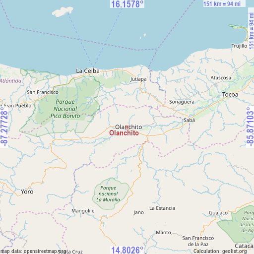
Olanchito GPS coordinates[2]
15° 28' 52.716" North, 86° 34' 26.94" West
| Map corner | latitude | longitude |
|---|---|---|
| Upper-left | 16.1578°, | -87.27728° |
| Center: | 15.48131°, | -86.57415° |
| Lower-right: | 14.8026°, | -85.87103° |
| Map W x H: | 150.7×150.7 km | = 93.6×93.6mi |
| max Lat: | 16.45° ⇑16.6% North |
| Olanchito: | 15.48131° |
| min Lat: | ⇓83.4% South 13.11667° |
| min Long | Olanchito | max Long |
| -89.23333° | -86.57415° | -83.23333° |
| W 83.4%⇐ | ⇒16.6% E |
Elevation
Elevation of Olanchito is 158 m = 518 ft, and this is 403.2 m = 1323 ft below average elevation for this country.
| Max E: |
1811 m = 5942 ft | 74.2% |
| Avg. | 561.2 m = 1841 ft | |
| Olanchito | 158 m = 518 ft | |
Min E: |
1 m = 3 ft | 25.8% |
See also: Honduras elevation on elevation.city.
Geographical zone
Olanchito is located in North Torrid zone (between Equator and Tropic of Cancer). Distance of this Northern Tropic circle is 884.6 km =549.7 mi to North.| Distance of | km | miles | from Olanchito |
|---|---|---|---|
| North Pole | 8285.7 | 5148.5 | to North |
| Arctic Circle | 5679.8 | 3529.3 | to North |
| Tropic Cancer | 884.6 | 549.7 | to North |
| Equator | 1721.4 | 1069.6 | to South |


Nearby cities:
15 places around Olanchito: (largest is in red/bold)
• Armenia
22.3 km =13.9 mi,  94°
94°
• Buenos Aires
18.7 km =11.6 mi, 94°
• Bálsamo Oriental
25.8 km =16 mi, 89°
• Carbajales
24.3 km =15.1 mi,  80°
80°
• Chirinos
9.1 km =5.7 mi,  186°
186°
• Coyoles
11.8 km =7.3 mi,  262°
262°
• Coyoles Central
13.4 km =8.3 mi,  227°
227°
• El Juncal
15.5 km =9.6 mi,  102°
102°
• El Ocote
7.2 km =4.5 mi,  173°
173°
• Elíxir
29.4 km =18.3 mi, 89°
• Nombre de Jesús
18.7 km =11.6 mi,  218°
218°
• Piedras Amarillas
22.5 km =14 mi,  2°
2°
• Teguajinal
13 km =8.1 mi, 192°
• Tepusteca
28.5 km =17.7 mi, 104°
• Trojas
19.9 km =12.4 mi, 222°
Sources, notices
• [Note1] Compared only with cities in Honduras existing in our database
• [Src1] Map data: © OpenStreetMap contributors (CC-BY-SA)
• [Src2] Other city data from geonames.org with taken over terms of usage.
• [Src3] Geographical zone / Annual Mean Temperature by Robert A. Rohde @ Wikipedia
