Corinto geodata
Corinto (Cortés) is a populated place; located in Honduras in America/Tegucigalpa (GMT-6) time zone. With population of 954 people, there are 446 cities with bigger population in this country. Compared to other cities in Honduras, 87% of cities are located further ↓South; 79.6% of cities are located further →East and 92% of cities have higher elevation than Corinto. Note1


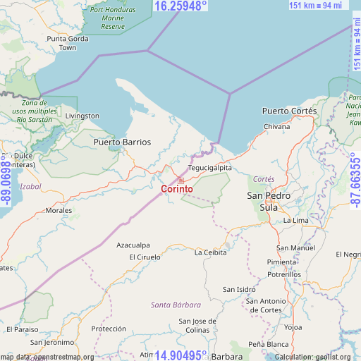
Corinto GPS coordinates[2]
15° 34' 59.988" North, 88° 22' 0.012" West
| Map corner | latitude | longitude |
|---|---|---|
| Upper-left | 16.25948°, | -89.0698° |
| Center: | 15.58333°, | -88.36667° |
| Lower-right: | 14.90495°, | -87.66355° |
| Map W x H: | 150.6×150.6 km | = 93.6×93.6mi |
| max Lat: | 16.45° ⇑13% North |
| Corinto: | 15.58333° |
| min Lat: | ⇓87% South 13.11667° |
| min Long | Corinto | max Long |
| -89.23333° | -88.36667° | -83.23333° |
| W 20.4%⇐ | ⇒79.6% E |
Elevation
Elevation of Corinto is 18 m = 59 ft, and this is 543.2 m = 1782 ft below average elevation for this country.
| Max E: |
1811 m = 5942 ft | 92% |
| Avg. | 561.2 m = 1841 ft | |
| Corinto | 18 m = 59 ft | |
Min E: |
1 m = 3 ft | 8% |
See also: Honduras elevation on elevation.city.
Geographical zone
Corinto is located in North Torrid zone (between Equator and Tropic of Cancer). Distance of this Northern Tropic circle is 873.2 km =542.6 mi to North.| Distance of | km | miles | from Corinto |
|---|---|---|---|
| North Pole | 8274.4 | 5141.5 | to North |
| Arctic Circle | 5668.5 | 3522.2 | to North |
| Tropic Cancer | 873.2 | 542.6 | to North |
| Equator | 1732.7 | 1076.6 | to South |


Nearby cities:
15 places around Corinto: (largest is in red/bold)
• Azacualpa
33.2 km =20.6 mi,  216°
216°
• Buenos Aires
22.6 km =14 mi,  119°
119°
• Camalote
28 km =17.4 mi,  172°
172°
• Cofradía
30.9 km =19.2 mi,  131°
131°
• Correderos
20.6 km =12.8 mi,  205°
205°
• Cuyamel
20.1 km =12.5 mi,  62°
62°
• La Esperanza
27 km =16.8 mi, 133°
• Loma Alta
29.3 km =18.2 mi, 224°
• Naco
29.7 km =18.5 mi,  138°
138°
• Pinalejo
22.5 km =14 mi,  189°
189°
• Potrerillos
9 km =5.6 mi,  52°
52°
• Quimistán
26.2 km =16.3 mi, 187°
• Río Chiquito
13.7 km =8.5 mi,  66°
66°
• San Marcos
32 km =19.9 mi, 189°
• Santa Cruz Minas
25.1 km =15.6 mi,  163°
163°
Sources, notices
• [Note1] Compared only with cities in Honduras existing in our database
• [Src1] Map data: © OpenStreetMap contributors (CC-BY-SA)
• [Src2] Other city data from geonames.org with taken over terms of usage.
• [Src3] Geographical zone / Annual Mean Temperature by Robert A. Rohde @ Wikipedia
