Armenia geodata
Armenia (Yoro) is a populated place; located in Honduras in America/Tegucigalpa (GMT-6) time zone. With population of 1,488 people, there are 241 cities with bigger population in this country. Compared to other cities in Honduras, 82.4% of cities are located further ↓South; 87.8% of cities are located further ←West and 77.4% of cities have higher elevation than Armenia. Note1


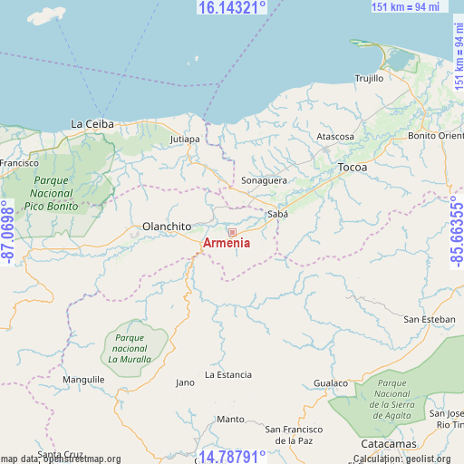
Armenia GPS coordinates[2]
15° 28' 0.012" North, 86° 22' 0.012" West
| Map corner | latitude | longitude |
|---|---|---|
| Upper-left | 16.14321°, | -87.0698° |
| Center: | 15.46667°, | -86.36667° |
| Lower-right: | 14.78791°, | -85.66355° |
| Map W x H: | 150.7×150.7 km | = 93.6×93.6mi |
| max Lat: | 16.45° ⇑17.6% North |
| Armenia: | 15.46667° |
| min Lat: | ⇓82.4% South 13.11667° |
| min Long | Armenia | max Long |
| -89.23333° | -86.36667° | -83.23333° |
| W 87.8%⇐ | ⇒12.2% E |
Elevation
Elevation of Armenia is 108 m = 354 ft, and this is 453.2 m = 1487 ft below average elevation for this country.
| Max E: |
1811 m = 5942 ft | 77.4% |
| Avg. | 561.2 m = 1841 ft | |
| Armenia | 108 m = 354 ft | |
Min E: |
1 m = 3 ft | 22.6% |
See also: Honduras elevation on elevation.city.
Geographical zone
Armenia is located in North Torrid zone (between Equator and Tropic of Cancer). Distance of this Northern Tropic circle is 886.2 km =550.7 mi to North.| Distance of | km | miles | from Armenia |
|---|---|---|---|
| North Pole | 8287.3 | 5149.5 | to North |
| Arctic Circle | 5681.4 | 3530.3 | to North |
| Tropic Cancer | 886.2 | 550.7 | to North |
| Equator | 1719.7 | 1068.6 | to South |


Nearby cities:
15 places around Armenia: (largest is in red/bold)
• Buenos Aires
3.6 km =2.2 mi,  270°
270°
• Bálsamo Oriental
4 km =2.5 mi,  62°
62°
• Carbajales
5.8 km =3.6 mi,  17°
17°
• Chirinos
24.4 km =15.2 mi,  252°
252°
• Coyoles
33.9 km =21.1 mi, 270°
• Coyoles Central
33 km =20.5 mi,  257°
257°
• El Juncal
7.4 km =4.6 mi, 255°
• El Ocote
22.1 km =13.7 mi, 255°
• Elíxir
7.4 km =4.6 mi,  75°
75°
• Olanchito
22.3 km =13.9 mi, 274°
• Piedras Amarillas
32.2 km =20 mi,  318°
318°
• Prieta
27.7 km =17.2 mi, 62°
• Sabá
12.5 km =7.8 mi,  90°
90°
• Teguajinal
27.4 km =17 mi, 246°
• Tepusteca
7.7 km =4.8 mi,  136°
136°
Sources, notices
• [Note1] Compared only with cities in Honduras existing in our database
• [Src1] Map data: © OpenStreetMap contributors (CC-BY-SA)
• [Src2] Other city data from geonames.org with taken over terms of usage.
• [Src3] Geographical zone / Annual Mean Temperature by Robert A. Rohde @ Wikipedia
