Elíxir geodata
Elíxir (Colón) is a populated place; located in Honduras in America/Tegucigalpa (GMT-6) time zone. With population of 3,079 people, there are 104 cities with bigger population in this country. Compared to other cities in Honduras, 83.6% of cities are located further ↓South; 89.6% of cities are located further ←West and 79.2% of cities have higher elevation than Elíxir. Note1


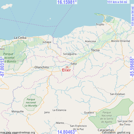
Elíxir GPS coordinates[2]
15° 28' 59.988" North, 86° 18' 0" West
| Map corner | latitude | longitude |
|---|---|---|
| Upper-left | 16.15981°, | -87.00313° |
| Center: | 15.48333°, | -86.3° |
| Lower-right: | 14.80463°, | -85.59688° |
| Map W x H: | 150.7×150.7 km | = 93.6×93.6mi |
| max Lat: | 16.45° ⇑16.4% North |
| Elíxir: | 15.48333° |
| min Lat: | ⇓83.6% South 13.11667° |
| min Long | Elíxir | max Long |
| -89.23333° | -86.3° | -83.23333° |
| W 89.6%⇐ | ⇒10.4% E |
Elevation
Elevation of Elíxir is 90 m = 295 ft, and this is 471.2 m = 1546 ft below average elevation for this country.
| Max E: |
1811 m = 5942 ft | 79.2% |
| Avg. | 561.2 m = 1841 ft | |
| Elíxir | 90 m = 295 ft | |
Min E: |
1 m = 3 ft | 20.8% |
See also: Honduras elevation on elevation.city.
Geographical zone
Elíxir is located in North Torrid zone (between Equator and Tropic of Cancer). Distance of this Northern Tropic circle is 884.3 km =549.5 mi to North.| Distance of | km | miles | from Elíxir |
|---|---|---|---|
| North Pole | 8285.5 | 5148.4 | to North |
| Arctic Circle | 5679.6 | 3529.1 | to North |
| Tropic Cancer | 884.3 | 549.5 | to North |
| Equator | 1721.6 | 1069.8 | to South |


Nearby cities:
15 places around Elíxir: (largest is in red/bold)
• Armenia
7.4 km =4.6 mi,  255°
255°
• Buenos Aires
10.9 km =6.8 mi, 260°
• Bálsamo Oriental
3.6 km =2.2 mi,  270°
270°
• Carbajales
6.5 km =4 mi,  304°
304°
• Chirinos
31.7 km =19.7 mi,  253°
253°
• El Juncal
14.8 km =9.2 mi, 255°
• El Ocote
29.5 km =18.3 mi, 255°
• Olanchito
29.4 km =18.3 mi, 269°
• Piedras Amarillas
36.2 km =22.5 mi,  307°
307°
• Prieta
20.6 km =12.8 mi,  58°
58°
• Río Esteban
38.9 km =24.2 mi,  0°
0°
• Sabá
5.7 km =3.5 mi,  109°
109°
• Teguajinal
34.7 km =21.6 mi, 248°
• Tepusteca
7.6 km =4.7 mi,  193°
193°
• Zamora
30 km =18.6 mi, 56°
Sources, notices
• [Note1] Compared only with cities in Honduras existing in our database
• [Src1] Map data: © OpenStreetMap contributors (CC-BY-SA)
• [Src2] Other city data from geonames.org with taken over terms of usage.
• [Src3] Geographical zone / Annual Mean Temperature by Robert A. Rohde @ Wikipedia
