Tepusteca geodata
Tepusteca (Yoro) is a populated place; located in Honduras in America/Tegucigalpa (GMT-6) time zone. With population of 1,638 people, there are 225 cities with bigger population in this country. Compared to other cities in Honduras, 80.2% of cities are located further ↓South; 89.4% of cities are located further ←West and 56.6% of cities have higher elevation than Tepusteca. Note1


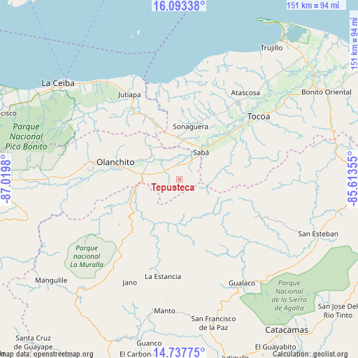
Tepusteca GPS coordinates[2]
15° 25' 0.012" North, 86° 19' 0.012" West
| Map corner | latitude | longitude |
|---|---|---|
| Upper-left | 16.09338°, | -87.0198° |
| Center: | 15.41667°, | -86.31667° |
| Lower-right: | 14.73775°, | -85.61355° |
| Map W x H: | 150.7×150.7 km | = 93.6×93.6mi |
| max Lat: | 16.45° ⇑19.8% North |
| Tepusteca: | 15.41667° |
| min Lat: | ⇓80.2% South 13.11667° |
| min Long | Tepusteca | max Long |
| -89.23333° | -86.31667° | -83.23333° |
| W 89.4%⇐ | ⇒10.6% E |
Elevation
Elevation of Tepusteca is 456 m = 1496 ft, and this is 105.2 m = 345 ft below average elevation for this country.
| Max E: |
1811 m = 5942 ft | 56.6% |
| Avg. | 561.2 m = 1841 ft | |
| Tepusteca | 456 m = 1496 ft | |
Min E: |
1 m = 3 ft | 43.4% |
See also: Honduras elevation on elevation.city.
Geographical zone
Tepusteca is located in North Torrid zone (between Equator and Tropic of Cancer). Distance of this Northern Tropic circle is 891.7 km =554.1 mi to North.| Distance of | km | miles | from Tepusteca |
|---|---|---|---|
| North Pole | 8292.9 | 5153 | to North |
| Arctic Circle | 5687 | 3533.7 | to North |
| Tropic Cancer | 891.7 | 554.1 | to North |
| Equator | 1714.2 | 1065.2 | to South |


Nearby cities:
15 places around Tepusteca: (largest is in red/bold)
• Armenia
7.7 km =4.8 mi,  316°
316°
• Buenos Aires
10.5 km =6.5 mi,  301°
301°
• Bálsamo Oriental
7.6 km =4.7 mi,  346°
346°
• Carbajales
11.7 km =7.3 mi,  342°
342°
• Chirinos
28.6 km =17.8 mi,  266°
266°
• Coyoles Central
37.6 km =23.4 mi, 267°
• El Juncal
13 km =8.1 mi,  286°
286°
• El Ocote
26.8 km =16.7 mi, 270°
• Elíxir
7.6 km =4.7 mi,  13°
13°
• La Guata
37.7 km =23.4 mi,  190°
190°
• Olanchito
28.5 km =17.7 mi,  284°
284°
• Prieta
26.5 km =16.5 mi,  46°
46°
• Sabá
9.1 km =5.7 mi, 52°
• Teguajinal
30.9 km =19.2 mi,  259°
259°
• Zamora
36 km =22.4 mi, 48°
Sources, notices
• [Note1] Compared only with cities in Honduras existing in our database
• [Src1] Map data: © OpenStreetMap contributors (CC-BY-SA)
• [Src2] Other city data from geonames.org with taken over terms of usage.
• [Src3] Geographical zone / Annual Mean Temperature by Robert A. Rohde @ Wikipedia
