Gualaco geodata
Gualaco (Olancho) is a populated place; located in Honduras in America/Tegucigalpa (GMT-6) time zone. With population of 3,601 people, there are 89 cities with bigger population in this country. Compared to other cities in Honduras, 59.4% of cities are located further ↓South; 92.4% of cities are located further ←West and 57.6% of cities have lower elevation than Gualaco. Note1


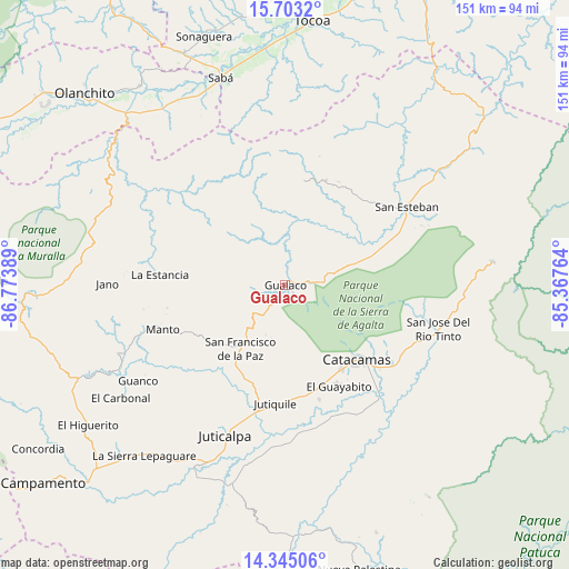
Gualaco GPS coordinates[2]
15° 1' 30.756" North, 86° 4' 14.736" West
| Map corner | latitude | longitude |
|---|---|---|
| Upper-left | 15.7032°, | -86.77389° |
| Center: | 15.02521°, | -86.07076° |
| Lower-right: | 14.34506°, | -85.36764° |
| Map W x H: | 151×151 km | = 93.8×93.8mi |
| max Lat: | 16.45° ⇑40.6% North |
| Gualaco: | 15.02521° |
| min Lat: | ⇓59.4% South 13.11667° |
| min Long | Gualaco | max Long |
| -89.23333° | -86.07076° | -83.23333° |
| W 92.4%⇐ | ⇒7.6% E |
Elevation
Elevation of Gualaco is 653 m = 2142 ft, and this is 91.8 m = 301 ft above average elevation for this country.
| Max E: |
1811 m = 5942 ft | 42.4% |
| Gualaco | 653 m 2142 ft | |
| Avg. | 561.2 m = 1841 ft | |
Min E: |
1 m = 3 ft | 57.6% |
See also: Honduras elevation on elevation.city.
Geographical zone
Gualaco is located in North Torrid zone (between Equator and Tropic of Cancer). Distance of this Northern Tropic circle is 935.3 km =581.2 mi to North.| Distance of | km | miles | from Gualaco |
|---|---|---|---|
| North Pole | 8336.4 | 5180 | to North |
| Arctic Circle | 5730.5 | 3560.8 | to North |
| Tropic Cancer | 935.3 | 581.2 | to North |
| Equator | 1670.6 | 1038.1 | to South |


Nearby cities:
15 places around Gualaco: (largest is in red/bold)
• Arimís
27.9 km =17.3 mi,  164°
164°
• El Guayabito
21.7 km =13.5 mi,  169°
169°
• Guarizama
30.7 km =19.1 mi,  246°
246°
• Jutiquile
34.3 km =21.3 mi,  182°
182°
• La Concepción
40.2 km =25 mi,  205°
205°
• La Empalizada
42.3 km =26.3 mi,  189°
189°
• La Estancia
30.1 km =18.7 mi,  275°
275°
• La Guata
34.2 km =21.3 mi, 280°
• Laguna Seca
36.3 km =22.6 mi, 184°
• Manto
35.7 km =22.2 mi, 250°
• Punuare
34.3 km =21.3 mi, 160°
• San Esteban
38.4 km =23.9 mi,  57°
57°
• San Francisco de la Paz
19.7 km =12.2 mi,  224°
224°
• San José de Río Tinto
41.1 km =25.5 mi,  104°
104°
• Santa María del Real
31.5 km =19.6 mi, 155°
Sources, notices
• [Note1] Compared only with cities in Honduras existing in our database
• [Src1] Map data: © OpenStreetMap contributors (CC-BY-SA)
• [Src2] Other city data from geonames.org with taken over terms of usage.
• [Src3] Geographical zone / Annual Mean Temperature by Robert A. Rohde @ Wikipedia
