Tučepi geodata
Tučepi (Split-Dalmatia) is a seat of a second-order administrative division; located in Croatia in Europe/Zagreb (GMT+2) time zone. With population of 1,772 people, there are 245 cities with bigger population in this country. Compared to other cities in Croatia, 95.3% of cities are located further ↑North; 68.8% of cities are located further ←West and 92% of cities have higher elevation than Tučepi. Note1


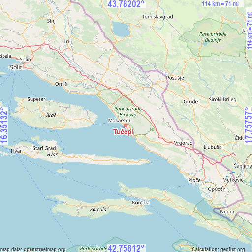
Tučepi GPS coordinates[2]
43° 16' 19.992" North, 17° 3' 15.984" East
| Map corner | latitude | longitude |
|---|---|---|
| Upper-left | 43.78202°, | 16.35132° |
| Center: | 43.27222°, | 17.05444° |
| Lower-right: | 42.75812°, | 17.75757° |
| Map W x H: | 113.8×113.8 km | = 70.7×70.7mi |
| max Lat: | 46.52694° ⇑95.3% North |
| Tučepi: | 43.27222° |
| min Lat: | ⇓4.7% South 42.54972° |
| min Long | Tučepi | max Long |
| 13.52389° | 17.05444° | 19.37694° |
| W 68.8%⇐ | ⇒31.2% E |
Elevation
Elevation of Tučepi is 16 m = 52 ft, and this is 137.3 m = 450 ft below average elevation for this country.
| Max E: |
827 m = 2713 ft | 92% |
| Avg. | 153.3 m = 503 ft | |
| Tučepi | 16 m = 52 ft | |
Min E: |
-1 m = -3 ft | 8% |
See also: Croatia elevation on elevation.city.
Geographical zone
Tučepi is located in North temperate zone (between Tropic of Cancer and the Arctic Circle). Distance of this Northern Tropic circle is 2205.5 km =1370.4 mi to South.| Distance of | km | miles | from Tučepi |
|---|---|---|---|
| North Pole | 5195.6 | 3228.4 | to North |
| Arctic Circle | 2589.8 | 1609.2 | to North |
| Tropic Cancer | 2205.5 | 1370.4 | to South |
| Equator | 4811.4 | 2989.7 | to South |


Nearby cities:
15 places around Tučepi: (largest is in red/bold)
• Baška Voda
12.6 km =7.8 mi,  318°
318°
• Brela
14.5 km =9 mi, 317°
• Grubine
19.6 km =12.2 mi,  26°
26°
• Kraj
23.2 km =14.4 mi,  129°
129°
• Lokvičič
21.5 km =13.4 mi,  8°
8°
• Makarska
4 km =2.5 mi,  312°
312°
• Podbablje
16.8 km =10.4 mi,  36°
36°
• Podgora
3.7 km =2.3 mi,  150°
150°
• Runović
18.8 km =11.7 mi,  51°
51°
• Selca
16.7 km =10.4 mi,  279°
279°
• Stražica
9.2 km =5.7 mi, 26°
• Sućuraj
19.5 km =12.1 mi, 146°
• Zadvarje
22.1 km =13.7 mi, 323°
• Zagvozd
13.9 km =8.6 mi,  0°
0°
• Zmijavci
19.7 km =12.2 mi, 38°
Sources, notices
• [Note1] Compared only with cities in Croatia existing in our database
• [Src1] Map data: © OpenStreetMap contributors (CC-BY-SA)
• [Src2] Other city data from geonames.org with taken over terms of usage.
• [Src3] Geographical zone / Annual Mean Temperature by Robert A. Rohde @ Wikipedia
