Stražica geodata
Stražica (Split-Dalmatia) is a populated place; located in Croatia in Europe/Zagreb (GMT+2) time zone. With population of 784 people, there are 614 cities with bigger population in this country. Compared to other cities in Croatia, 94.9% of cities are located further ↑North; 69.5% of cities are located further ←West and 99.5% of cities have lower elevation than Stražica. Note1


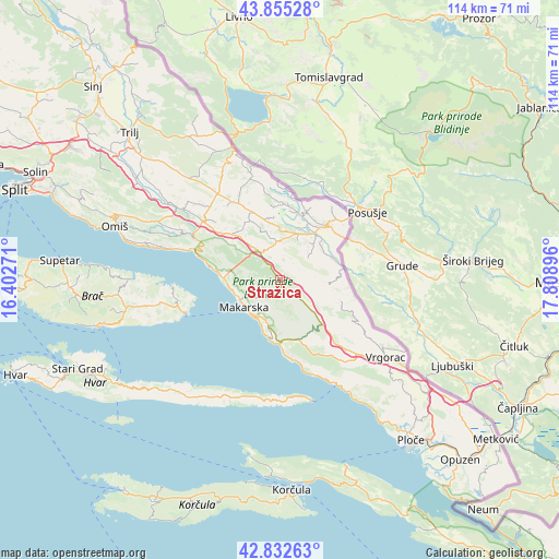
Stražica GPS coordinates[2]
43° 20' 45.996" North, 17° 6' 20.988" East
| Map corner | latitude | longitude |
|---|---|---|
| Upper-left | 43.85528°, | 16.40271° |
| Center: | 43.34611°, | 17.10583° |
| Lower-right: | 42.83263°, | 17.80896° |
| Map W x H: | 113.7×113.7 km | = 70.6×70.6mi |
| max Lat: | 46.52694° ⇑94.9% North |
| Stražica: | 43.34611° |
| min Lat: | ⇓5.1% South 42.54972° |
| min Long | Stražica | max Long |
| 13.52389° | 17.10583° | 19.37694° |
| W 69.5%⇐ | ⇒30.5% E |
Elevation
Elevation of Stražica is 765 m = 2510 ft, and this is 611.7 m = 2007 ft above average elevation for this country.
| Max E: |
827 m = 2713 ft | 0.5% |
| Stražica | 765 m 2510 ft | |
| Avg. | 153.3 m = 503 ft | |
Min E: |
-1 m = -3 ft | 99.5% |
See also: Croatia elevation on elevation.city.
Geographical zone
Stražica is located in North temperate zone (between Tropic of Cancer and the Arctic Circle). Distance of this Northern Tropic circle is 2213.7 km =1375.5 mi to South.| Distance of | km | miles | from Stražica |
|---|---|---|---|
| North Pole | 5187.4 | 3223.3 | to North |
| Arctic Circle | 2581.5 | 1604.1 | to North |
| Tropic Cancer | 2213.7 | 1375.5 | to South |
| Equator | 4819.6 | 2994.8 | to South |


Nearby cities:
15 places around Stražica: (largest is in red/bold)
• Baška Voda
12.6 km =7.8 mi,  275°
275°
• Brela
14.1 km =8.8 mi, 280°
• Donji Proložac
14.3 km =8.9 mi,  16°
16°
• Donji Vinjani
15.6 km =9.7 mi,  44°
44°
• Grabovci
18 km =11.2 mi,  25°
25°
• Grubine
10.4 km =6.5 mi, 26°
• Imotski
14.3 km =8.9 mi, 38°
• Lokvičič
13.1 km =8.1 mi,  354°
354°
• Makarska
9 km =5.6 mi,  232°
232°
• Podbablje
7.9 km =4.9 mi,  48°
48°
• Podgora
11.7 km =7.3 mi,  191°
191°
• Runović
11.1 km =6.9 mi,  72°
72°
• Tučepi
9.2 km =5.7 mi,  206°
206°
• Zagvozd
6.9 km =4.3 mi,  325°
325°
• Zmijavci
10.8 km =6.7 mi, 48°
Sources, notices
• [Note1] Compared only with cities in Croatia existing in our database
• [Src1] Map data: © OpenStreetMap contributors (CC-BY-SA)
• [Src2] Other city data from geonames.org with taken over terms of usage.
• [Src3] Geographical zone / Annual Mean Temperature by Robert A. Rohde @ Wikipedia
