Baška Voda geodata
Baška Voda (Split-Dalmatia) is a seat of a second-order administrative division; located in Croatia in Europe/Zagreb (GMT+2) time zone. With population of 2,924 people, there are 143 cities with bigger population in this country. Compared to other cities in Croatia, 94.6% of cities are located further ↑North; 67.1% of cities are located further ←West and 94.3% of cities have higher elevation than Baška Voda. Note1


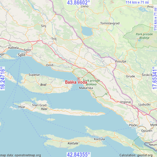
Baška Voda GPS coordinates[2]
43° 21' 24.984" North, 16° 57' 1.008" East
| Map corner | latitude | longitude |
|---|---|---|
| Upper-left | 43.86602°, | 16.24716° |
| Center: | 43.35694°, | 16.95028° |
| Lower-right: | 42.84355°, | 17.65341° |
| Map W x H: | 113.7×113.7 km | = 70.6×70.6mi |
| max Lat: | 46.52694° ⇑94.6% North |
| Baška Voda: | 43.35694° |
| min Lat: | ⇓5.4% South 42.54972° |
| min Long | Baška Voda | max Long |
| 13.52389° | 16.95028° | 19.37694° |
| W 67.1%⇐ | ⇒32.9% E |
Elevation
Elevation of Baška Voda is 11 m = 36 ft, and this is 142.3 m = 467 ft below average elevation for this country.
| Max E: |
827 m = 2713 ft | 94.3% |
| Avg. | 153.3 m = 503 ft | |
| Baška Voda | 11 m = 36 ft | |
Min E: |
-1 m = -3 ft | 5.7% |
See also: Croatia elevation on elevation.city.
Geographical zone
Baška Voda is located in North temperate zone (between Tropic of Cancer and the Arctic Circle). Distance of this Northern Tropic circle is 2214.9 km =1376.3 mi to South.| Distance of | km | miles | from Baška Voda |
|---|---|---|---|
| North Pole | 5186.2 | 3222.6 | to North |
| Arctic Circle | 2580.3 | 1603.3 | to North |
| Tropic Cancer | 2214.9 | 1376.3 | to South |
| Equator | 4820.8 | 2995.5 | to South |


Nearby cities:
15 places around Baška Voda: (largest is in red/bold)
• Brela
1.9 km =1.2 mi,  315°
315°
• Cista Provo
16.3 km =10.1 mi,  359°
359°
• Katuni
12.7 km =7.9 mi,  340°
340°
• Kostanje
13.3 km =8.3 mi,  314°
314°
• Kučiće
14.8 km =9.2 mi,  304°
304°
• Lokvičič
16.4 km =10.2 mi,  43°
43°
• Lovreć
14.8 km =9.2 mi,  11°
11°
• Makarska
8.6 km =5.3 mi,  140°
140°
• Podgora
16.3 km =10.1 mi, 140°
• Selca
10.4 km =6.5 mi,  230°
230°
• Stražica
12.6 km =7.8 mi,  95°
95°
• Tučepi
12.6 km =7.8 mi, 138°
• Zadvarje
9.6 km =6 mi,  329°
329°
• Zagvozd
9.7 km =6 mi,  62°
62°
• Šestanovac
11.3 km =7 mi, 343°
Sources, notices
• [Note1] Compared only with cities in Croatia existing in our database
• [Src1] Map data: © OpenStreetMap contributors (CC-BY-SA)
• [Src2] Other city data from geonames.org with taken over terms of usage.
• [Src3] Geographical zone / Annual Mean Temperature by Robert A. Rohde @ Wikipedia
