Brela geodata
Brela (Split-Dalmatia) is a seat of a second-order administrative division; located in Croatia in Europe/Zagreb (GMT+2) time zone. With population of 1,626 people, there are 267 cities with bigger population in this country. Compared to other cities in Croatia, 94.5% of cities are located further ↑North; 66.5% of cities are located further ←West and 84.7% of cities have higher elevation than Brela. Note1


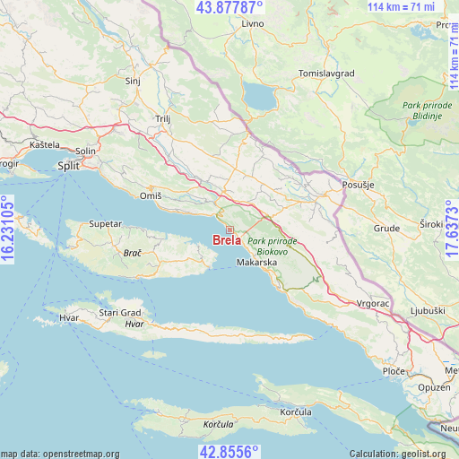
Brela GPS coordinates[2]
43° 22' 8.004" North, 16° 56' 3.012" East
| Map corner | latitude | longitude |
|---|---|---|
| Upper-left | 43.87787°, | 16.23105° |
| Center: | 43.36889°, | 16.93417° |
| Lower-right: | 42.8556°, | 17.6373° |
| Map W x H: | 113.7×113.7 km | = 70.6×70.6mi |
| max Lat: | 46.52694° ⇑94.5% North |
| Brela: | 43.36889° |
| min Lat: | ⇓5.5% South 42.54972° |
| min Long | Brela | max Long |
| 13.52389° | 16.93417° | 19.37694° |
| W 66.5%⇐ | ⇒33.5% E |
Elevation
Elevation of Brela is 70 m = 230 ft, and this is 83.3 m = 273 ft below average elevation for this country.
| Max E: |
827 m = 2713 ft | 84.7% |
| Avg. | 153.3 m = 503 ft | |
| Brela | 70 m = 230 ft | |
Min E: |
-1 m = -3 ft | 15.3% |
See also: Croatia elevation on elevation.city.
Geographical zone
Brela is located in North temperate zone (between Tropic of Cancer and the Arctic Circle). Distance of this Northern Tropic circle is 2216.2 km =1377.1 mi to South.| Distance of | km | miles | from Brela |
|---|---|---|---|
| North Pole | 5184.9 | 3221.7 | to North |
| Arctic Circle | 2579 | 1602.5 | to North |
| Tropic Cancer | 2216.2 | 1377.1 | to South |
| Equator | 4822.2 | 2996.4 | to South |


Nearby cities:
15 places around Brela: (largest is in red/bold)
• Baška Voda
1.9 km =1.2 mi,  135°
135°
• Cista Provo
15 km =9.3 mi,  4°
4°
• Katuni
11 km =6.8 mi,  344°
344°
• Kostanje
11.4 km =7.1 mi,  314°
314°
• Kučiće
13 km =8.1 mi,  303°
303°
• Lokvičič
16.5 km =10.3 mi,  50°
50°
• Lovreć
13.9 km =8.6 mi,  17°
17°
• Makarska
10.5 km =6.5 mi, 139°
• Pučišća
16.4 km =10.2 mi,  261°
261°
• Selca
10.4 km =6.5 mi,  220°
220°
• Stražica
14.1 km =8.8 mi,  100°
100°
• Tučepi
14.5 km =9 mi, 137°
• Zadvarje
7.8 km =4.8 mi,  332°
332°
• Zagvozd
10.4 km =6.5 mi,  72°
72°
• Šestanovac
9.7 km =6 mi,  349°
349°
Sources, notices
• [Note1] Compared only with cities in Croatia existing in our database
• [Src1] Map data: © OpenStreetMap contributors (CC-BY-SA)
• [Src2] Other city data from geonames.org with taken over terms of usage.
• [Src3] Geographical zone / Annual Mean Temperature by Robert A. Rohde @ Wikipedia
