Sunja geodata
Sunja (Sisačko-Moslavačka) is a seat of a second-order administrative division; located in Croatia in Europe/Zagreb (GMT+2) time zone. With population of 1,404 people, there are 319 cities with bigger population in this country. Compared to other cities in Croatia, 54.1% of cities are located further ↑North; 54.6% of cities are located further ←West and 66.2% of cities have higher elevation than Sunja. Note1


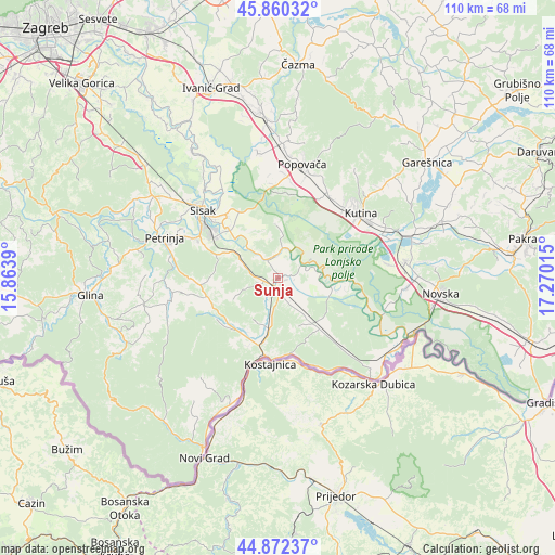
Sunja GPS coordinates[2]
45° 22' 6.6" North, 16° 34' 1.272" East
| Map corner | latitude | longitude |
|---|---|---|
| Upper-left | 45.86032°, | 15.8639° |
| Center: | 45.3685°, | 16.56702° |
| Lower-right: | 44.87237°, | 17.27015° |
| Map W x H: | 109.8×109.8 km | = 68.2×68.2mi |
| max Lat: | 46.52694° ⇑54.1% North |
| Sunja: | 45.3685° |
| min Lat: | ⇓45.9% South 42.54972° |
| min Long | Sunja | max Long |
| 13.52389° | 16.56702° | 19.37694° |
| W 54.6%⇐ | ⇒45.4% E |
Elevation
Elevation of Sunja is 101 m = 331 ft, and this is 52.3 m = 172 ft below average elevation for this country.
| Max E: |
827 m = 2713 ft | 66.2% |
| Avg. | 153.3 m = 503 ft | |
| Sunja | 101 m = 331 ft | |
Min E: |
-1 m = -3 ft | 33.8% |
See also: Croatia elevation on elevation.city.
Geographical zone
Sunja is located in North temperate zone (between Tropic of Cancer and the Arctic Circle). Distance of this North polar circle is 2356.7 km =1464.4 mi to North.| Distance of | km | miles | from Sunja |
|---|---|---|---|
| North Pole | 4962.6 | 3083.6 | to North |
| Arctic Circle | 2356.7 | 1464.4 | to North |
| Tropic Cancer | 2438.6 | 1515.3 | to South |
| Equator | 5044.5 | 3134.5 | to South |


Nearby cities:
15 places around Sunja: (largest is in red/bold)
• Budaševo
15.6 km =9.7 mi,  319°
319°
• Donja Gračenica
16.6 km =10.3 mi,  31°
31°
• Donji Kukuruzari
13.1 km =8.1 mi,  209°
209°
• Gornja Gračenica
18.9 km =11.7 mi, 32°
• Gornje Komarevo
12.3 km =7.6 mi,  293°
293°
• Hrastelnica
18.9 km =11.7 mi, 321°
• Hrvatska Kostajnica
15.4 km =9.6 mi,  188°
188°
• Kutina
20.5 km =12.7 mi,  54°
54°
• Majur
12.9 km =8 mi, 192°
• Osekovo
16.9 km =10.5 mi,  13°
13°
• Potok
20.1 km =12.5 mi, 5°
• Repušnica
18.8 km =11.7 mi,  42°
42°
• Sisak
18.3 km =11.4 mi,  306°
306°
• Stružec
17.7 km =11 mi,  356°
356°
• Topolovac
14.5 km =9 mi, 314°
Sources, notices
• [Note1] Compared only with cities in Croatia existing in our database
• [Src1] Map data: © OpenStreetMap contributors (CC-BY-SA)
• [Src2] Other city data from geonames.org with taken over terms of usage.
• [Src3] Geographical zone / Annual Mean Temperature by Robert A. Rohde @ Wikipedia
