Stružec geodata
Stružec (Sisačko-Moslavačka) is a populated place; located in Croatia in Europe/Zagreb (GMT+2) time zone. With population of 687 people, there are 676 cities with bigger population in this country. Compared to other cities in Croatia, 55.3% of cities are located further ↓South; 54.1% of cities are located further ←West and 51.6% of cities have lower elevation than Stružec. Note1


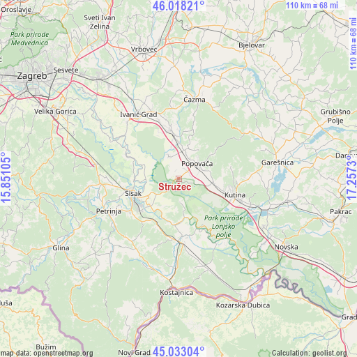
Stružec GPS coordinates[2]
45° 31' 40.008" North, 16° 33' 15.012" East
| Map corner | latitude | longitude |
|---|---|---|
| Upper-left | 46.01821°, | 15.85105° |
| Center: | 45.52778°, | 16.55417° |
| Lower-right: | 45.03304°, | 17.2573° |
| Map W x H: | 109.5×109.5 km | = 68×68mi |
| max Lat: | 46.52694° ⇑44.7% North |
| Stružec: | 45.52778° |
| min Lat: | ⇓55.3% South 42.54972° |
| min Long | Stružec | max Long |
| 13.52389° | 16.55417° | 19.37694° |
| W 54.1%⇐ | ⇒45.9% E |
Elevation
Elevation of Stružec is 130 m = 427 ft, and this is 23.3 m = 76 ft below average elevation for this country.
| Max E: |
827 m = 2713 ft | 48.4% |
| Avg. | 153.3 m = 503 ft | |
| Stružec | 130 m = 427 ft | |
Min E: |
-1 m = -3 ft | 51.6% |
See also: Croatia elevation on elevation.city.
Geographical zone
Stružec is located in North temperate zone (between Tropic of Cancer and the Arctic Circle). Distance of this North polar circle is 2339 km =1453.4 mi to North.| Distance of | km | miles | from Stružec |
|---|---|---|---|
| North Pole | 4944.8 | 3072.6 | to North |
| Arctic Circle | 2339 | 1453.4 | to North |
| Tropic Cancer | 2456.3 | 1526.3 | to South |
| Equator | 5062.2 | 3145.5 | to South |


Nearby cities:
15 places around Stružec: (largest is in red/bold)
• Budaševo
10.9 km =6.8 mi,  237°
237°
• Donja Gračenica
10.4 km =6.5 mi,  110°
110°
• Gornja Gračenica
11.2 km =7 mi,  98°
98°
• Gornja Jelenska
13.8 km =8.6 mi,  54°
54°
• Hrastelnica
11 km =6.8 mi,  255°
255°
• Novoselec
13.9 km =8.6 mi,  354°
354°
• Obedišće
11.7 km =7.3 mi,  0°
0°
• Osekovo
5 km =3.1 mi, 104°
• Popovača
7.2 km =4.5 mi, 49°
• Potok
3.7 km =2.3 mi, 50°
• Strelečko
13.3 km =8.3 mi,  265°
265°
• Topolovac
11.9 km =7.4 mi,  230°
230°
• Velika Ludina
8.8 km =5.5 mi,  23°
23°
• Vidrenjak
9.4 km =5.8 mi,  9°
9°
• Voloder
10 km =6.2 mi,  76°
76°
Sources, notices
• [Note1] Compared only with cities in Croatia existing in our database
• [Src1] Map data: © OpenStreetMap contributors (CC-BY-SA)
• [Src2] Other city data from geonames.org with taken over terms of usage.
• [Src3] Geographical zone / Annual Mean Temperature by Robert A. Rohde @ Wikipedia
