Suhopolje geodata
Suhopolje (Virovitičk-Podravska) is a seat of a second-order administrative division; located in Croatia in Europe/Zagreb (GMT+2) time zone. With population of 2,879 people, there are 147 cities with bigger population in this country. Compared to other cities in Croatia, 71.8% of cities are located further ↓South; 76% of cities are located further ←West and 55.1% of cities have higher elevation than Suhopolje. Note1


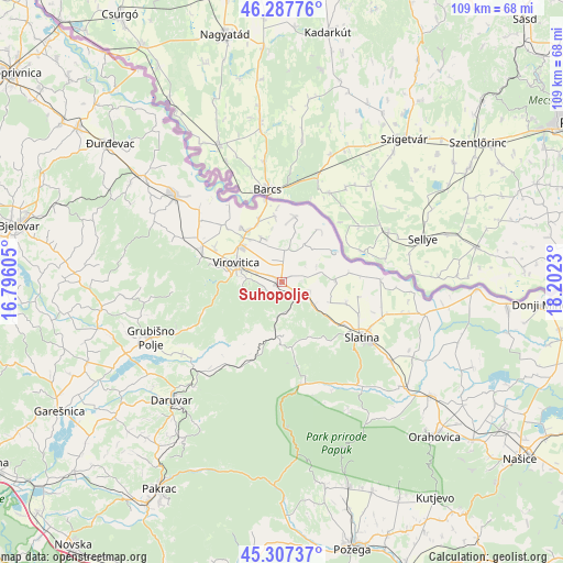
Suhopolje GPS coordinates[2]
45° 47' 58.992" North, 17° 29' 57.012" East
| Map corner | latitude | longitude |
|---|---|---|
| Upper-left | 46.28776°, | 16.79605° |
| Center: | 45.79972°, | 17.49917° |
| Lower-right: | 45.30737°, | 18.2023° |
| Map W x H: | 109×109 km | = 67.7×67.7mi |
| max Lat: | 46.52694° ⇑28.2% North |
| Suhopolje: | 45.79972° |
| min Lat: | ⇓71.8% South 42.54972° |
| min Long | Suhopolje | max Long |
| 13.52389° | 17.49917° | 19.37694° |
| W 76%⇐ | ⇒24% E |
Elevation
Elevation of Suhopolje is 117 m = 384 ft, and this is 36.3 m = 119 ft below average elevation for this country.
| Max E: |
827 m = 2713 ft | 55.1% |
| Avg. | 153.3 m = 503 ft | |
| Suhopolje | 117 m = 384 ft | |
Min E: |
-1 m = -3 ft | 44.9% |
See also: Croatia elevation on elevation.city.
Geographical zone
Suhopolje is located in North temperate zone (between Tropic of Cancer and the Arctic Circle). Distance of this North polar circle is 2308.7 km =1434.6 mi to North.| Distance of | km | miles | from Suhopolje |
|---|---|---|---|
| North Pole | 4914.6 | 3053.8 | to North |
| Arctic Circle | 2308.7 | 1434.6 | to North |
| Tropic Cancer | 2486.5 | 1545 | to South |
| Equator | 5092.5 | 3164.3 | to South |


Nearby cities:
15 places around Suhopolje: (largest is in red/bold)
• Bakić
16 km =9.9 mi,  114°
114°
• Borova
3.3 km =2.1 mi,  242°
242°
• Bušetina
15.5 km =9.6 mi,  314°
314°
• Cabuna
8 km =5 mi,  129°
129°
• Dugo Selo Lukačko
8 km =5 mi,  332°
332°
• Gradina
6.2 km =3.9 mi,  5°
5°
• Lukač
10.2 km =6.3 mi,  322°
322°
• Rezovac
6.7 km =4.2 mi,  254°
254°
• Sladojevci
15 km =9.3 mi,  124°
124°
• Slatina
19.1 km =11.9 mi, 124°
• Sopje
18.9 km =11.7 mi,  89°
89°
• Turanovac
13.2 km =8.2 mi, 322°
• Virovitica
9.6 km =6 mi,  291°
291°
• Ðulovac
15.7 km =9.8 mi,  198°
198°
• Špišić-Bukovica
16.7 km =10.4 mi, 292°
Sources, notices
• [Note1] Compared only with cities in Croatia existing in our database
• [Src1] Map data: © OpenStreetMap contributors (CC-BY-SA)
• [Src2] Other city data from geonames.org with taken over terms of usage.
• [Src3] Geographical zone / Annual Mean Temperature by Robert A. Rohde @ Wikipedia
