Slatina geodata
Slatina (Virovitičk-Podravska) is a seat of a second-order administrative division; located in Croatia in Europe/Zagreb (GMT+2) time zone. With population of 10,973 people, there are 38 cities with bigger population in this country. Compared to other cities in Croatia, 65.4% of cities are located further ↓South; 78.2% of cities are located further ←West and 51.7% of cities have higher elevation than Slatina. Note1


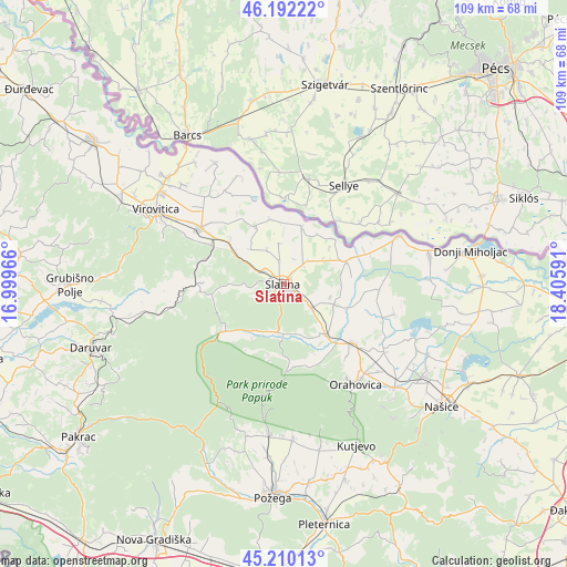
Slatina GPS coordinates[2]
45° 42' 11.988" North, 17° 42' 10.008" East
| Map corner | latitude | longitude |
|---|---|---|
| Upper-left | 46.19222°, | 16.99966° |
| Center: | 45.70333°, | 17.70278° |
| Lower-right: | 45.21013°, | 18.40591° |
| Map W x H: | 109.2×109.2 km | = 67.9×67.9mi |
| max Lat: | 46.52694° ⇑34.6% North |
| Slatina: | 45.70333° |
| min Lat: | ⇓65.4% South 42.54972° |
| min Long | Slatina | max Long |
| 13.52389° | 17.70278° | 19.37694° |
| W 78.2%⇐ | ⇒21.8% E |
Elevation
Elevation of Slatina is 124 m = 407 ft, and this is 29.3 m = 96 ft below average elevation for this country.
| Max E: |
827 m = 2713 ft | 51.7% |
| Avg. | 153.3 m = 503 ft | |
| Slatina | 124 m = 407 ft | |
Min E: |
-1 m = -3 ft | 48.3% |
See also: Croatia elevation on elevation.city.
Geographical zone
Slatina is located in North temperate zone (between Tropic of Cancer and the Arctic Circle). Distance of this North polar circle is 2319.4 km =1441.2 mi to North.| Distance of | km | miles | from Slatina |
|---|---|---|---|
| North Pole | 4925.3 | 3060.4 | to North |
| Arctic Circle | 2319.4 | 1441.2 | to North |
| Tropic Cancer | 2475.8 | 1538.4 | to South |
| Equator | 5081.7 | 3157.6 | to South |


Nearby cities:
15 places around Slatina: (largest is in red/bold)
• Bakić
4.4 km =2.7 mi,  343°
343°
• Borova
20.9 km =13 mi,  296°
296°
• Cabuna
11.2 km =7 mi, 300°
• Crnac
18.2 km =11.3 mi,  92°
92°
• Kozice
3.3 km =2.1 mi,  133°
133°
• Mikleuš
12.3 km =7.6 mi,  140°
140°
• Nova Bukovica
6.6 km =4.1 mi, 130°
• Sladojevci
4.1 km =2.5 mi, 303°
• Sopje
11.3 km =7 mi,  15°
15°
• Suhopolje
19.1 km =11.9 mi, 304°
• Voćin
15.3 km =9.5 mi,  231°
231°
• Ðulovac
21.3 km =13.2 mi,  258°
258°
• Ćeralije
9.4 km =5.8 mi,  188°
188°
• Čačinci
17.1 km =10.6 mi, 130°
• Čađavica
12.6 km =7.8 mi,  68°
68°
Sources, notices
• [Note1] Compared only with cities in Croatia existing in our database
• [Src1] Map data: © OpenStreetMap contributors (CC-BY-SA)
• [Src2] Other city data from geonames.org with taken over terms of usage.
• [Src3] Geographical zone / Annual Mean Temperature by Robert A. Rohde @ Wikipedia
