Slavonski Šamac geodata
Slavonski Šamac (Slavonski Brod-Posavina) is a seat of a second-order administrative division; located in Croatia in Europe/Zagreb (GMT+2) time zone. In our database, there are 904 cities with bigger population. Compared to other cities in Croatia, 74.4% of cities are located further ↑North; 90% of cities are located further ←West and 82% of cities have higher elevation than Slavonski Šamac. Note1


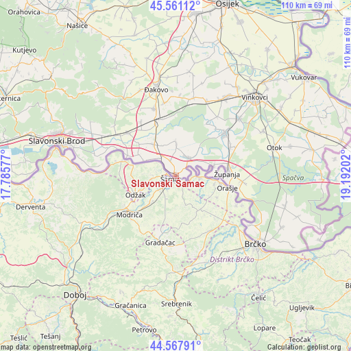
Slavonski Šamac GPS coordinates[2]
45° 4' 0.012" North, 18° 29' 20.004" East
| Map corner | latitude | longitude |
|---|---|---|
| Upper-left | 45.56112°, | 17.78577° |
| Center: | 45.06667°, | 18.48889° |
| Lower-right: | 44.56791°, | 19.19202° |
| Map W x H: | 110.4×110.4 km | = 68.6×68.6mi |
| max Lat: | 46.52694° ⇑74.4% North |
| Slavonski Šamac: | 45.06667° |
| min Lat: | ⇓25.6% South 42.54972° |
| min Long | Slavonski Šama | max Long |
| 13.52389° | 18.48889° | 19.37694° |
| W 90%⇐ | ⇒10% E |
Elevation
Elevation of Slavonski Šamac is 83 m = 272 ft, and this is 70.3 m = 231 ft below average elevation for this country.
| Max E: |
827 m = 2713 ft | 82% |
| Avg. | 153.3 m = 503 ft | |
| Slavonski Šamac | 83 m = 272 ft | |
Min E: |
-1 m = -3 ft | 18% |
See also: Croatia elevation on elevation.city.
Geographical zone
Slavonski Šamac is located in North temperate zone (between Tropic of Cancer and the Arctic Circle). Distance of this North polar circle is 2390.2 km =1485.2 mi to North.| Distance of | km | miles | from Slavonski Šamac |
|---|---|---|---|
| North Pole | 4996.1 | 3104.4 | to North |
| Arctic Circle | 2390.2 | 1485.2 | to North |
| Tropic Cancer | 2405 | 1494.4 | to South |
| Equator | 5010.9 | 3113.6 | to South |


Nearby cities:
15 places around Slavonski Šamac: (largest is in red/bold)
• Babina Greda
6.8 km =4.2 mi,  33°
33°
• Beravci
10.5 km =6.5 mi,  333°
333°
• Gradište
19.3 km =12 mi,  62°
62°
• Gundinci
10.2 km =6.3 mi,  1°
1°
• Jaruge
7.7 km =4.8 mi,  315°
315°
• Kruševica
1.3 km =0.8 mi,  338°
338°
• Prkovci
19 km =11.8 mi, 30°
• Sikirevci
5.1 km =3.2 mi, 337°
• Strizivojna
18.4 km =11.4 mi, 343°
• Velika Kopanica
12.5 km =7.8 mi, 322°
• Vrpolje
17.3 km =10.7 mi, 337°
• Čajkovci
17.3 km =10.7 mi, 325°
• Šiškovci
19.2 km =11.9 mi,  40°
40°
• Štitar
12.3 km =7.6 mi,  74°
74°
• Županja
16.4 km =10.2 mi,  85°
85°
Sources, notices
• [Note1] Compared only with cities in Croatia existing in our database
• [Src1] Map data: © OpenStreetMap contributors (CC-BY-SA)
• [Src2] Other city data from geonames.org with taken over terms of usage.
• [Src3] Geographical zone / Annual Mean Temperature by Robert A. Rohde @ Wikipedia
